This weather event on August 17, 2025 includes:
1 states
14 counties,
18 cities,
and 70 zip codes.
There were total properties that were impacted and have possible damage.
States Impacted By Hail On August 17, 2025
Illinois
Counties Impacted By Hail On August 17, 2025
Champaign, IL
·
Christian, IL
·
De Witt, IL
·
Grundy, IL
·
Livingston, IL
·
Logan, IL
·
Macon, IL
·
Mason, IL
·
McLean, IL
·
Menard, IL
·
Peoria, IL
·
Piatt, IL
·
Sangamon, IL
·
Tazewell, IL
Cities Impacted By Hail On August 17, 2025
Braceville, IL
·
Carbon Hill, IL
·
Clinton, IL
·
Coal City, IL
·
Danvers, IL
·
Dawson, IL
·
Decatur, IL
·
Diamond, IL
·
East Peoria, IL
·
Fairbury, IL
·
Forsyth, IL
·
Lincoln, IL
·
Mansfield, IL
·
Mechanicsburg, IL
·
Mount Auburn, IL
·
Mount Pulaski, IL
·
Pekin, IL
·
Warrensburg, IL
Zip Codes Impacted By Hail On August 17, 2025
60407
·
60416
·
60424
·
60444
·
60450
·
61311
·
61319
·
61333
·
61364
·
61517
·
61529
·
61532
·
61534
·
61546
·
61554
·
61559
·
61568
·
61571
·
61611
·
61721
·
61723
·
61724
·
61727
·
61732
·
61734
·
61735
·
61739
·
61750
·
61755
·
61756
·
61764
·
61842
·
61843
·
61853
·
62512
·
62515
·
62520
·
62526
·
62531
·
62535
·
62539
·
62541
·
62543
·
62545
·
62547
·
62548
·
62551
·
62554
·
62561
·
62563
·
62573
·
62613
·
62633
·
62634
·
62635
·
62643
·
62656
·
62664
·
62666
·
62671
·
62682
·
62684
·
62693
·
62702
·
62703
·
62707
·
62711
·
62712
·
61749
·
61854
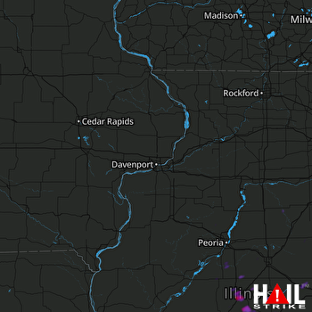 DAVENPORT (KDVN) RADAR

