This weather event on August 16, 2025 includes:
3 states
14 counties,
19 cities,
and 53 zip codes.
There were 176 total properties that were impacted and have possible damage.
States Impacted By Hail On August 16, 2025
Illinois
·
Indiana
·
Michigan
Counties Impacted By Hail On August 16, 2025
Champaign, IL
·
Ford, IL
·
Iroquois, IL
·
Livingston, IL
·
Vermilion, IL
·
Will, IL
·
Fountain, IN
·
Montgomery, IN
·
Parke, IN
·
Putnam, IN
·
Tippecanoe, IN
·
Warren, IN
·
White, IN
·
Berrien, MI
Cities Impacted By Hail On August 16, 2025
Alamo, IN
·
Berrien Springs, MI
·
Bismarck, IL
·
Buckley, IL
·
Chalmers, IN
·
Chatsworth, IL
·
Cissna Park, IL
·
Covington, IN
·
Hoopeston, IL
·
New Richmond, IN
·
Plainfield, IL
·
Rankin, IL
·
Roberts, IL
·
Russellville, IN
·
Shadeland, IN
·
Veedersburg, IN
·
Wallace, IN
·
Waveland, IN
·
West Point, IN
Zip Codes Impacted By Hail On August 16, 2025
46135
·
46172
·
46175
·
47832
·
47859
·
47872
·
47906
·
47909
·
47916
·
47918
·
47920
·
47923
·
47929
·
47932
·
47933
·
47949
·
47952
·
47967
·
47981
·
47987
·
47989
·
47990
·
47992
·
47993
·
49102
·
49103
·
49104
·
49126
·
60544
·
60586
·
60918
·
60924
·
60926
·
60929
·
60932
·
60942
·
60948
·
60952
·
60953
·
60955
·
60959
·
60960
·
60962
·
60963
·
60968
·
60973
·
61741
·
61769
·
61814
·
61834
·
61862
·
61865
·
60921
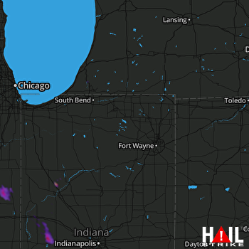 FORT WAYNE (KIWX) RADAR

