This weather event on August 15, 2025 includes:
4 states
27 counties,
15 cities,
and 47 zip codes.
There were 1349 total properties that were impacted and have possible damage.
States Impacted By Hail On August 15, 2025
Georgia
·
North Carolina
·
South Carolina
·
Tennessee
Counties Impacted By Hail On August 15, 2025
Barrow, GA
·
Elbert, GA
·
Franklin, GA
·
Glascock, GA
·
Hart, GA
·
Jackson, GA
·
Lincoln, GA
·
McDuffie, GA
·
Warren, GA
·
Washington, GA
·
Wilkes, GA
·
Avery, NC
·
Gaston, NC
·
Graham, NC
·
Mecklenburg, NC
·
Abbeville, SC
·
Cherokee, SC
·
Chester, SC
·
Edgefield, SC
·
Laurens, SC
·
Lexington, SC
·
McCormick, SC
·
Newberry, SC
·
Richland, SC
·
Union, SC
·
York, SC
·
Carter, TN
Cities Impacted By Hail On August 15, 2025
Belmont, NC
·
Carlisle, SC
·
Commerce, GA
·
Cross Hill, SC
·
Franklin Springs, GA
·
Gastonia, NC
·
Laurens, SC
·
Mountville, SC
·
Newport, SC
·
Parksville, SC
·
Richburg, SC
·
Royston, GA
·
Statham, GA
·
Washington, GA
·
Waterloo, SC
Zip Codes Impacted By Hail On August 15, 2025
28012
·
28056
·
28278
·
28622
·
28771
·
29031
·
29037
·
29054
·
29145
·
29203
·
29207
·
29332
·
29340
·
29355
·
29360
·
29370
·
29379
·
29384
·
29655
·
29706
·
29710
·
29729
·
29732
·
29742
·
29745
·
29824
·
29838
·
29844
·
29845
·
30520
·
30521
·
30529
·
30549
·
30635
·
30662
·
30666
·
30668
·
30673
·
30810
·
30817
·
30820
·
30824
·
30828
·
31018
·
37687
·
30557
·
29835
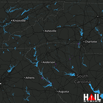 GREER (KGSP) RADAR

