This weather event on August 14, 2025 includes:
3 states
9 counties,
32 cities,
and 95 zip codes.
There were total properties that were impacted and have possible damage.
States Impacted By Hail On August 14, 2025
Massachusetts
·
New York
·
Rhode Island
Counties Impacted By Hail On August 14, 2025
Bristol, MA
·
Hampden, MA
·
Norfolk, MA
·
Plymouth, MA
·
Suffolk, MA
·
Worcester, MA
·
Orange, NY
·
Sullivan, NY
·
Providence, RI
Cities Impacted By Hail On August 14, 2025
Abington, MA
·
Agawam Town, MA
·
Attleboro, MA
·
Boston, MA
·
Braintree Town, MA
·
Bridgewater, MA
·
Brockton, MA
·
Brookline, MA
·
Central Falls, RI
·
Chicopee, MA
·
Dedham, MA
·
Dover, MA
·
Foster Center, RI
·
Foxborough, MA
·
Hingham, MA
·
Holbrook, MA
·
Hull, MA
·
Milford, MA
·
Milton, MA
·
Needham, MA
·
Norton Center, MA
·
Norwood, MA
·
Pawtucket, RI
·
Providence, RI
·
Quincy, MA
·
Randolph, MA
·
Southfield, MA
·
Springfield, MA
·
Taunton, MA
·
Westfield, MA
·
West Springfield Town, MA
·
Weymouth Town, MA
Zip Codes Impacted By Hail On August 14, 2025
1008
·
1013
·
1020
·
1030
·
1071
·
1085
·
1089
·
1097
·
1104
·
1109
·
1151
·
1568
·
1747
·
1757
·
2026
·
2030
·
2035
·
2043
·
2052
·
2056
·
2061
·
2067
·
2071
·
2081
·
2090
·
2093
·
2115
·
2118
·
2119
·
2120
·
2121
·
2122
·
2124
·
2125
·
2126
·
2127
·
2130
·
2131
·
2132
·
2136
·
2169
·
2170
·
2171
·
2184
·
2186
·
2188
·
2189
·
2190
·
2191
·
2215
·
2302
·
2324
·
2333
·
2339
·
2341
·
2343
·
2346
·
2368
·
2370
·
2382
·
2445
·
2446
·
2467
·
2492
·
2703
·
2717
·
2760
·
2762
·
2766
·
2780
·
2815
·
2825
·
2826
·
2830
·
2831
·
2857
·
2860
·
2861
·
2863
·
2865
·
2896
·
2903
·
2904
·
2905
·
2906
·
2907
·
2908
·
2909
·
2911
·
12566
·
12721
·
1077
·
2021
·
2062
·
2351
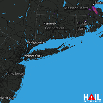 NEW YORK CITY (KOKX) RADAR

