This weather event on August 13, 2025 includes:
4 states
19 counties,
15 cities,
and 96 zip codes.
There were 529 total properties that were impacted and have possible damage.
States Impacted By Hail On August 13, 2025
Massachusetts
·
Maine
·
New Hampshire
·
Vermont
Counties Impacted By Hail On August 13, 2025
Essex, MA
·
Middlesex, MA
·
Franklin, ME
·
Oxford, ME
·
Piscataquis, ME
·
Somerset, ME
·
Carroll, NH
·
Cheshire, NH
·
Coos, NH
·
Grafton, NH
·
Hillsborough, NH
·
Merrimack, NH
·
Strafford, NH
·
Sullivan, NH
·
Addison, VT
·
Orange, VT
·
Washington, VT
·
Windham, VT
·
Windsor, VT
Cities Impacted By Hail On August 13, 2025
Amherst, NH
·
Andover, MA
·
Berlin, NH
·
Bradford, VT
·
Concord, NH
·
East Pepperell, MA
·
Fairlee, VT
·
Manchester, NH
·
Mexico, ME
·
Pepperell, MA
·
Pinardville, NH
·
Putney, VT
·
Rumford, ME
·
South Royalton, VT
·
Townsend, MA
Zip Codes Impacted By Hail On August 13, 2025
1450
·
1463
·
1469
·
1810
·
1845
·
3031
·
3033
·
3057
·
3070
·
3102
·
3104
·
3106
·
3221
·
3222
·
3223
·
3224
·
3234
·
3244
·
3245
·
3264
·
3266
·
3279
·
3280
·
3281
·
3282
·
3301
·
3307
·
3440
·
3445
·
3446
·
3448
·
3456
·
3457
·
3464
·
3465
·
3467
·
3570
·
3581
·
3593
·
3605
·
3752
·
3768
·
3777
·
3872
·
3887
·
4216
·
4217
·
4219
·
4226
·
4257
·
4261
·
4275
·
4276
·
4285
·
4406
·
4441
·
4442
·
4464
·
4478
·
4920
·
4947
·
4961
·
4966
·
4982
·
4983
·
4985
·
5001
·
5033
·
5036
·
5039
·
5045
·
5048
·
5058
·
5060
·
5065
·
5068
·
5070
·
5072
·
5075
·
5077
·
5079
·
5146
·
5148
·
5151
·
5301
·
5343
·
5346
·
5353
·
5359
·
5669
·
5674
·
5747
·
5748
·
5767
·
3045
·
3779
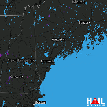 PORTLAND (KGYX) RADAR

