This weather event on August 13, 2025 includes:
2 states
19 counties,
12 cities,
and 84 zip codes.
There were 439 total properties that were impacted and have possible damage.
States Impacted By Hail On August 13, 2025
New York
·
Vermont
Counties Impacted By Hail On August 13, 2025
Albany, NY
·
Columbia, NY
·
Essex, NY
·
Fulton, NY
·
Greene, NY
·
Hamilton, NY
·
Rensselaer, NY
·
Saratoga, NY
·
Schoharie, NY
·
Warren, NY
·
Washington, NY
·
Addison, VT
·
Bennington, VT
·
Caledonia, VT
·
Orange, VT
·
Rutland, VT
·
Washington, VT
·
Windham, VT
·
Windsor, VT
Cities Impacted By Hail On August 13, 2025
Arlington, VT
·
Fort Edward, NY
·
Hudson Falls, NY
·
Manchester, VT
·
Manchester Center, VT
·
Montpelier, VT
·
Northville, NY
·
Ravena, NY
·
South Shaftsbury, VT
·
Warrensburg, NY
·
Westport, NY
·
Whitehall, NY
Zip Codes Impacted By Hail On August 13, 2025
5031
·
5032
·
5045
·
5046
·
5048
·
5065
·
5068
·
5072
·
5077
·
5079
·
5142
·
5146
·
5201
·
5250
·
5251
·
5252
·
5253
·
5254
·
5255
·
5257
·
5261
·
5262
·
5340
·
5343
·
5350
·
5352
·
5353
·
5359
·
5602
·
5663
·
5679
·
5701
·
5743
·
5751
·
5776
·
5862
·
12033
·
12041
·
12043
·
12045
·
12046
·
12054
·
12057
·
12059
·
12067
·
12074
·
12117
·
12124
·
12134
·
12143
·
12156
·
12158
·
12161
·
12173
·
12186
·
12190
·
12193
·
12803
·
12804
·
12810
·
12814
·
12815
·
12822
·
12824
·
12827
·
12828
·
12831
·
12833
·
12835
·
12839
·
12844
·
12845
·
12850
·
12865
·
12878
·
12885
·
12887
·
12928
·
12932
·
12993
·
13459
·
5641
·
12025
·
12846
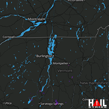 BURLINGTON (KCXX) RADAR

