This weather event on August 13, 2025 includes:
1 states
22 counties,
16 cities,
and 53 zip codes.
There were 1118 total properties that were impacted and have possible damage.
States Impacted By Hail On August 13, 2025
Texas
Counties Impacted By Hail On August 13, 2025
Bosque, TX
·
Delta, TX
·
Ellis, TX
·
Franklin, TX
·
Henderson, TX
·
Hill, TX
·
Hopkins, TX
·
Hunt, TX
·
Johnson, TX
·
Kaufman, TX
·
Lamar, TX
·
Limestone, TX
·
Navarro, TX
·
Palo Pinto, TX
·
Red River, TX
·
Smith, TX
·
Somervell, TX
·
Tarrant, TX
·
Titus, TX
·
Upshur, TX
·
Van Zandt, TX
·
Wood, TX
Cities Impacted By Hail On August 13, 2025
Big Sandy, TX
·
Burleson, TX
·
Gilmer, TX
·
Hawkins, TX
·
Holly Lake Ranch, TX
·
Mansfield, TX
·
Mineola, TX
·
Mount Pleasant, TX
·
Mount Vernon, TX
·
Neylandville, TX
·
Rendon, TX
·
Seven Points, TX
·
Talco, TX
·
Van, TX
·
Waxahachie, TX
·
Winnsboro, TX
Zip Codes Impacted By Hail On August 13, 2025
75103
·
75143
·
75158
·
75165
·
75167
·
75401
·
75416
·
75417
·
75422
·
75428
·
75431
·
75435
·
75450
·
75455
·
75457
·
75462
·
75468
·
75471
·
75478
·
75487
·
75493
·
75494
·
75497
·
75644
·
75645
·
75686
·
75704
·
75706
·
75754
·
75755
·
75765
·
75771
·
75773
·
75783
·
75790
·
75792
·
76028
·
76043
·
76063
·
76472
·
76621
·
76627
·
76635
·
76636
·
76641
·
76645
·
76648
·
76651
·
76652
·
76666
·
76673
·
76676
·
76690
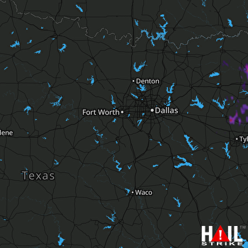 DALLAS/FTW (KFWS) RADAR

