This weather event on August 12, 2025 includes:
4 states
32 counties,
14 cities,
and 70 zip codes.
There were 4817 total properties that were impacted and have possible damage.
States Impacted By Hail On August 12, 2025
Arkansas
·
Louisiana
·
Missouri
·
Mississippi
Counties Impacted By Hail On August 12, 2025
Bradley, AR
·
Calhoun, AR
·
Chicot, AR
·
Clay, AR
·
Cleburne, AR
·
Cleveland, AR
·
Columbia, AR
·
Craighead, AR
·
Crawford, AR
·
Franklin, AR
·
Greene, AR
·
Howard, AR
·
Jackson, AR
·
Lawrence, AR
·
Lonoke, AR
·
Monroe, AR
·
Montgomery, AR
·
Ouachita, AR
·
Pike, AR
·
Poinsett, AR
·
Polk, AR
·
Pulaski, AR
·
Randolph, AR
·
Sharp, AR
·
St. Francis, AR
·
Union, AR
·
Van Buren, AR
·
White, AR
·
Woodruff, AR
·
Union, LA
·
Ripley, MO
·
Washington, MS
Cities Impacted By Hail On August 12, 2025
Brinkley, AR
·
Camden, AR
·
Fairfield Bay, AR
·
Fargo, AR
·
Gibson, AR
·
Jacksonville, AR
·
Lafe, AR
·
Leland, MS
·
McAlmont, AR
·
North Little Rock, AR
·
Oden, AR
·
Sherwood, AR
·
Shirley, AR
·
Wheatley, AR
Zip Codes Impacted By Hail On August 12, 2025
38701
·
38703
·
38723
·
38748
·
38756
·
63935
·
63942
·
71260
·
71277
·
71640
·
71651
·
71652
·
71701
·
71726
·
71744
·
71753
·
71758
·
71764
·
71833
·
71852
·
71953
·
71958
·
71959
·
71961
·
71971
·
72005
·
72006
·
72007
·
72013
·
72020
·
72021
·
72023
·
72031
·
72069
·
72076
·
72088
·
72099
·
72101
·
72112
·
72114
·
72116
·
72117
·
72119
·
72120
·
72153
·
72347
·
72392
·
72404
·
72410
·
72416
·
72417
·
72421
·
72427
·
72429
·
72432
·
72435
·
72436
·
72443
·
72450
·
72459
·
72472
·
72482
·
72543
·
72554
·
72946
·
72947
·
72949
·
72959
·
72118
·
72086
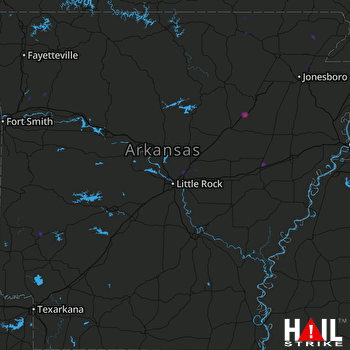 LITTLE ROCK (KLZK) RADAR

