This weather event on August 11, 2025 includes:
2 states
29 counties,
14 cities,
and 59 zip codes.
There were 3160 total properties that were impacted and have possible damage.
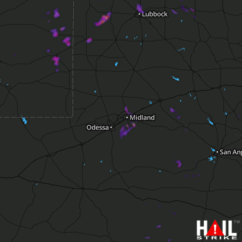 MIDLAND/ODSSA (KMAF) RADAR
States Impacted By Hail On August 11, 2025
New Mexico
·
Texas
Counties Impacted By Hail On August 11, 2025
Chaves, NM
·
Eddy, NM
·
Lea, NM
·
Roosevelt, NM
·
Andrews, TX
·
Bailey, TX
·
Cochran, TX
·
Crockett, TX
·
Crosby, TX
·
Dickens, TX
·
Ector, TX
·
Floyd, TX
·
Glasscock, TX
·
Hockley, TX
·
Howard, TX
·
Irion, TX
·
Lamb, TX
·
Lubbock, TX
·
Martin, TX
·
Midland, TX
·
Mitchell, TX
·
Pecos, TX
·
Runnels, TX
·
Schleicher, TX
·
Sterling, TX
·
Terrell, TX
·
Upton, TX
·
Val Verde, TX
·
Yoakum, TX
Cities Impacted By Hail On August 11, 2025
Causey, NM
·
Crosbyton, TX
·
Dickens, TX
·
Gardendale, TX
·
Levelland, TX
·
Littlefield, TX
·
Lovington, NM
·
Lubbock, TX
·
Midland, TX
·
New Deal, TX
·
Odessa, TX
·
Plains, TX
·
Sundown, TX
·
Tatum, NM
Zip Codes Impacted By Hail On August 11, 2025
76936
·
76941
·
76943
·
76951
·
78837
·
78851
·
78871
·
79229
·
79235
·
79243
·
79312
·
79322
·
79336
·
79339
·
79344
·
79346
·
79347
·
79350
·
79353
·
79355
·
79370
·
79371
·
79372
·
79376
·
79379
·
79403
·
79404
·
79415
·
79567
·
79705
·
79706
·
79707
·
79714
·
79720
·
79741
·
79744
·
79755
·
79758
·
79764
·
79765
·
79766
·
79781
·
79782
·
79783
·
88113
·
88116
·
88125
·
88132
·
88201
·
88203
·
88210
·
88240
·
88260
·
88262
·
88267
·
76930
·
79220
·
79762
·
88114

