This weather event on August 3, 2025 includes:
3 states
32 counties,
23 cities,
and 65 zip codes.
There were 4222 total properties that were impacted and have possible damage.
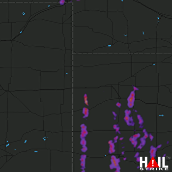 GOODLAND (KGLD) RADAR
States Impacted By Hail On August 3, 2025
Colorado
·
Kansas
·
Nebraska
Counties Impacted By Hail On August 3, 2025
Baca, CO
·
Sedgwick, CO
·
Finney, KS
·
Ford, KS
·
Gove, KS
·
Grant, KS
·
Gray, KS
·
Greeley, KS
·
Hamilton, KS
·
Haskell, KS
·
Hodgeman, KS
·
Kearny, KS
·
Lane, KS
·
Logan, KS
·
Morton, KS
·
Ness, KS
·
Pawnee, KS
·
Rush, KS
·
Scott, KS
·
Seward, KS
·
Sheridan, KS
·
Sherman, KS
·
Stanton, KS
·
Stevens, KS
·
Thomas, KS
·
Wallace, KS
·
Wichita, KS
·
Arthur, NE
·
Deuel, NE
·
Garden, NE
·
Keith, NE
·
McPherson, NE
Cities Impacted By Hail On August 3, 2025
Big Springs, NE
·
Brule, NE
·
Dighton, KS
·
Dodge City, KS
·
Garden City, KS
·
Grainfield, KS
·
Greeley County unified government (balance), KS
·
Grinnell, KS
·
Healy, KS
·
Holcomb, KS
·
Horace, KS
·
Hoxie, KS
·
Jetmore, KS
·
Johnson City, KS
·
Julesburg, CO
·
La Crosse, KS
·
Lewellen, NE
·
Manter, KS
·
Satanta, KS
·
Scott City, KS
·
Sharon Springs, KS
·
Syracuse, KS
·
Tribune, KS
Zip Codes Impacted By Hail On August 3, 2025
67513
·
67516
·
67518
·
67523
·
67547
·
67548
·
67556
·
67559
·
67560
·
67575
·
67584
·
67701
·
67732
·
67733
·
67735
·
67736
·
67737
·
67738
·
67740
·
67743
·
67748
·
67752
·
67758
·
67761
·
67764
·
67801
·
67835
·
67838
·
67839
·
67841
·
67846
·
67849
·
67850
·
67851
·
67853
·
67854
·
67855
·
67857
·
67860
·
67861
·
67862
·
67868
·
67870
·
67871
·
67876
·
67877
·
67878
·
67879
·
67880
·
67882
·
67952
·
67953
·
69121
·
69122
·
69127
·
69129
·
69144
·
69146
·
69147
·
69153
·
69155
·
69165
·
80737
·
80744
·
81090

