This weather event on July 30, 2025 includes:
1 states
10 counties,
14 cities,
and 98 zip codes.
There were 1460 total properties that were impacted and have possible damage.
States Impacted By Hail On July 30, 2025
Maine
Counties Impacted By Hail On July 30, 2025
Aroostook, ME
·
Franklin, ME
·
Hancock, ME
·
Kennebec, ME
·
Knox, ME
·
Penobscot, ME
·
Piscataquis, ME
·
Somerset, ME
·
Waldo, ME
·
Washington, ME
Cities Impacted By Hail On July 30, 2025
Belfast, ME
·
Calais, ME
·
Clinton, ME
·
Ellsworth, ME
·
Houlton, ME
·
Howland, ME
·
Mapleton, ME
·
Millinocket, ME
·
Norridgewock, ME
·
Presque Isle, ME
·
Searsport, ME
·
Skowhegan, ME
·
Southwest Harbor, ME
·
Unity, ME
Zip Codes Impacted By Hail On July 30, 2025
4408
·
4414
·
4415
·
4417
·
4418
·
4421
·
4430
·
4441
·
4442
·
4443
·
4448
·
4451
·
4455
·
4457
·
4459
·
4460
·
4462
·
4463
·
4464
·
4471
·
4472
·
4475
·
4476
·
4478
·
4487
·
4490
·
4492
·
4493
·
4495
·
4497
·
4605
·
4612
·
4614
·
4619
·
4625
·
4630
·
4637
·
4653
·
4679
·
4684
·
4686
·
4694
·
4730
·
4732
·
4733
·
4735
·
4739
·
4740
·
4747
·
4757
·
4758
·
4760
·
4761
·
4763
·
4764
·
4765
·
4766
·
4768
·
4769
·
4776
·
4777
·
4780
·
4786
·
4787
·
4847
·
4848
·
4849
·
4856
·
4862
·
4911
·
4915
·
4920
·
4921
·
4922
·
4925
·
4927
·
4936
·
4937
·
4938
·
4942
·
4945
·
4952
·
4957
·
4961
·
4966
·
4973
·
4974
·
4976
·
4981
·
4983
·
4986
·
4987
·
4988
·
4617
·
4654
·
4734
·
4951
·
4985
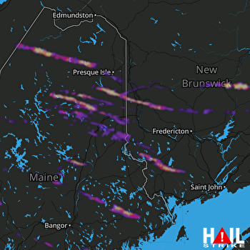 HOULTON (KCBW) RADAR

