This weather event on July 25, 2025 includes:
4 states
21 counties,
19 cities,
and 78 zip codes.
There were 89 total properties that were impacted and have possible damage.
States Impacted By Hail On July 25, 2025
Iowa
·
Kansas
·
Missouri
·
Nebraska
Counties Impacted By Hail On July 25, 2025
Decatur, IA
·
Allen, KS
·
Anderson, KS
·
Butler, KS
·
Chase, KS
·
Coffey, KS
·
Franklin, KS
·
Greenwood, KS
·
Lyon, KS
·
Marshall, KS
·
Miami, KS
·
Morris, KS
·
Nemaha, KS
·
Osage, KS
·
Pottawatomie, KS
·
Wabaunsee, KS
·
Woodson, KS
·
Adair, MO
·
Cass, MO
·
Schuyler, MO
·
Pawnee, NE
Cities Impacted By Hail On July 25, 2025
Axtell, KS
·
Belton, MO
·
Cassoday, KS
·
Council Grove, KS
·
Emporia, KS
·
Freeman, MO
·
Lebo, KS
·
Lee's Summit, MO
·
Madison, KS
·
Neosho Falls, KS
·
Oneida, KS
·
Osawatomie, KS
·
Ottawa, KS
·
Paola, KS
·
Peculiar, MO
·
Pleasant Hill, MO
·
Raymore, MO
·
Table Rock, NE
·
Wellsville, KS
Zip Codes Impacted By Hail On July 25, 2025
50067
·
50140
·
63501
·
63546
·
63561
·
64012
·
64078
·
64080
·
64082
·
64701
·
64734
·
64742
·
64746
·
66015
·
66032
·
66033
·
66039
·
66042
·
66053
·
66064
·
66067
·
66071
·
66078
·
66079
·
66080
·
66091
·
66092
·
66093
·
66095
·
66403
·
66404
·
66408
·
66423
·
66431
·
66451
·
66510
·
66522
·
66524
·
66528
·
66534
·
66535
·
66538
·
66547
·
66549
·
66748
·
66761
·
66783
·
66801
·
66833
·
66834
·
66839
·
66840
·
66843
·
66845
·
66846
·
66850
·
66852
·
66853
·
66856
·
66857
·
66860
·
66862
·
66865
·
66868
·
66869
·
66870
·
66871
·
67042
·
67045
·
67074
·
67132
·
68376
·
68420
·
68447
·
66842
·
66758
·
64083
·
50065
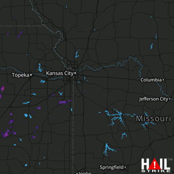 KANSAS CITY (KEAX) RADAR

