This weather event on July 24, 2025 includes:
3 states
26 counties,
16 cities,
and 73 zip codes.
There were 8226 total properties that were impacted and have possible damage.
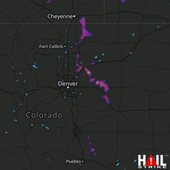 DENVER (KFTG) RADAR
States Impacted By Hail On July 24, 2025
Colorado
·
Nebraska
·
Wyoming
Counties Impacted By Hail On July 24, 2025
Adams, CO
·
Arapahoe, CO
·
Custer, CO
·
Douglas, CO
·
Elbert, CO
·
El Paso, CO
·
Fremont, CO
·
Jefferson, CO
·
Larimer, CO
·
Lincoln, CO
·
Morgan, CO
·
Otero, CO
·
Park, CO
·
Pueblo, CO
·
Saguache, CO
·
Teller, CO
·
Washington, CO
·
Weld, CO
·
Banner, NE
·
Cheyenne, NE
·
Deuel, NE
·
Scotts Bluff, NE
·
Albany, WY
·
Goshen, WY
·
Laramie, WY
·
Platte, WY
Cities Impacted By Hail On July 24, 2025
Aristocrat Ranchettes, CO
·
Ault, CO
·
Avondale, CO
·
Bennett, CO
·
Deer Trail, CO
·
Evans, CO
·
Fort Lupton, CO
·
Garden City, CO
·
Gilcrest, CO
·
Greeley, CO
·
Hudson, CO
·
Keenesburg, CO
·
La Salle, CO
·
Peoria, CO
·
Pierce, CO
·
Pueblo, CO
Zip Codes Impacted By Hail On July 24, 2025
69128
·
69129
·
69145
·
69156
·
69341
·
69352
·
80101
·
80102
·
80103
·
80105
·
80106
·
80117
·
80136
·
80456
·
80512
·
80517
·
80532
·
80536
·
80543
·
80603
·
80610
·
80611
·
80615
·
80620
·
80621
·
80623
·
80631
·
80634
·
80642
·
80643
·
80645
·
80648
·
80649
·
80650
·
80651
·
80652
·
80701
·
80723
·
80729
·
80757
·
80804
·
80808
·
80827
·
80828
·
80835
·
80863
·
80928
·
80930
·
81004
·
81005
·
81008
·
81022
·
81023
·
81025
·
81039
·
81067
·
81069
·
81131
·
81143
·
81223
·
81252
·
81253
·
82007
·
82051
·
82053
·
82054
·
82072
·
82201
·
82240
·
82244
·
69345
·
80135
·
81001

