This weather event on July 21, 2025 includes:
3 states
26 counties,
10 cities,
and 55 zip codes.
There were 2182 total properties that were impacted and have possible damage.
States Impacted By Hail On July 21, 2025
New Mexico
·
Oklahoma
·
Texas
Counties Impacted By Hail On July 21, 2025
Curry, NM
·
Guadalupe, NM
·
Quay, NM
·
Roosevelt, NM
·
San Miguel, NM
·
Beaver, OK
·
Ellis, OK
·
Harper, OK
·
Armstrong, TX
·
Briscoe, TX
·
Carson, TX
·
Crosby, TX
·
Floyd, TX
·
Gray, TX
·
Hall, TX
·
Hemphill, TX
·
Hutchinson, TX
·
Lipscomb, TX
·
Lubbock, TX
·
Motley, TX
·
Ochiltree, TX
·
Potter, TX
·
Randall, TX
·
Roberts, TX
·
Swisher, TX
·
Terry, TX
Cities Impacted By Hail On July 21, 2025
Amarillo, TX
·
Brownfield, TX
·
Claude, TX
·
Crosbyton, TX
·
Lubbock, TX
·
New Deal, TX
·
Quitaque, TX
·
Skellytown, TX
·
Tucumcari, NM
·
White Deer, TX
Zip Codes Impacted By Hail On July 21, 2025
73843
·
73848
·
79005
·
79014
·
79015
·
79019
·
79024
·
79034
·
79039
·
79046
·
79059
·
79065
·
79068
·
79070
·
79080
·
79088
·
79097
·
79107
·
79108
·
79110
·
79118
·
79226
·
79234
·
79235
·
79239
·
79241
·
79255
·
79257
·
79261
·
79316
·
79322
·
79356
·
79357
·
79363
·
79370
·
79403
·
79404
·
79407
·
79410
·
79412
·
79413
·
79415
·
79416
·
79423
·
88101
·
88116
·
88120
·
88121
·
88124
·
88125
·
88126
·
88130
·
88401
·
88416
·
88431
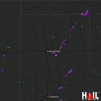 AMARILLO (KAMA) RADAR

