This weather event on July 12, 2025 includes:
2 states
21 counties,
19 cities,
and 71 zip codes.
There were total properties that were impacted and have possible damage.
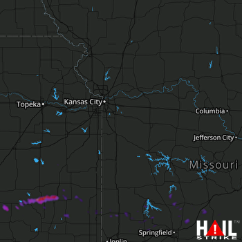 KANSAS CITY (KEAX) RADAR
States Impacted By Hail On July 12, 2025
Kansas
·
Missouri
Counties Impacted By Hail On July 12, 2025
Allen, KS
·
Anderson, KS
·
Bourbon, KS
·
Crawford, KS
·
Elk, KS
·
Greenwood, KS
·
Montgomery, KS
·
Neosho, KS
·
Wilson, KS
·
Woodson, KS
·
Barton, MO
·
Cedar, MO
·
Dade, MO
·
Dallas, MO
·
Greene, MO
·
Jasper, MO
·
Laclede, MO
·
Lawrence, MO
·
Polk, MO
·
Webster, MO
·
Wright, MO
Cities Impacted By Hail On July 12, 2025
Arma, KS
·
Buffalo, KS
·
Chanute, KS
·
Conway, MO
·
Coyville, KS
·
Fair Grove, MO
·
Franklin, KS
·
Girard, KS
·
Goodnight, MO
·
Greenfield, MO
·
Halfway, MO
·
Hepler, KS
·
Lamar, MO
·
Liberal, MO
·
Lockwood, MO
·
Phillipsburg, MO
·
Pleasant Hope, MO
·
Severy, KS
·
Stockton, MO
Zip Codes Impacted By Hail On July 12, 2025
64755
·
64756
·
64759
·
64762
·
64769
·
64836
·
64859
·
65470
·
65536
·
65543
·
65590
·
65604
·
65613
·
65622
·
65632
·
65635
·
65646
·
65648
·
65650
·
65661
·
65662
·
65663
·
65667
·
65682
·
65706
·
65707
·
65711
·
65713
·
65722
·
65725
·
65752
·
65757
·
65770
·
65785
·
66091
·
66093
·
66710
·
66712
·
66714
·
66717
·
66720
·
66732
·
66733
·
66735
·
66736
·
66740
·
66743
·
66746
·
66748
·
66749
·
66751
·
66755
·
66762
·
66771
·
66772
·
66775
·
66777
·
66779
·
66780
·
67047
·
67122
·
67301
·
67349
·
67352
·
67357
·
67137
·
66783
·
66756
·
65644
·
64862
·
64748

