This weather event on July 11, 2025 includes:
1 states
15 counties,
25 cities,
and 43 zip codes.
There were 2422 total properties that were impacted and have possible damage.
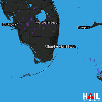 MIAMI (KAMX) RADAR
States Impacted By Hail On July 11, 2025
Florida
Counties Impacted By Hail On July 11, 2025
Broward, FL
·
Charlotte, FL
·
Collier, FL
·
DeSoto, FL
·
Glades, FL
·
Hendry, FL
·
Highlands, FL
·
Indian River, FL
·
Lee, FL
·
Martin, FL
·
Miami-Dade, FL
·
Monroe, FL
·
Okeechobee, FL
·
Palm Beach, FL
·
St. Lucie, FL
Cities Impacted By Hail On July 11, 2025
Alva, FL
·
Belle Glade, FL
·
Buckingham, FL
·
Canal Point, FL
·
Coral Terrace, FL
·
Fellsmere, FL
·
Fort Myers, FL
·
Fort Myers Shores, FL
·
Gateway, FL
·
Glenvar Heights, FL
·
Immokalee, FL
·
LaBelle, FL
·
Lehigh Acres, FL
·
Montura, FL
·
Olga, FL
·
Pahokee, FL
·
Pioneer, FL
·
Port LaBelle, FL
·
South Bay, FL
·
Southeast Arcadia, FL
·
South Miami, FL
·
The Acreage, FL
·
Wellington, FL
·
West Palm Beach, FL
·
West Vero Corridor, FL
Zip Codes Impacted By Hail On July 11, 2025
32966
·
32967
·
32968
·
33143
·
33155
·
33194
·
33412
·
33430
·
33438
·
33440
·
33470
·
33471
·
33476
·
33493
·
33857
·
33905
·
33912
·
33913
·
33920
·
33928
·
33930
·
33935
·
33936
·
33944
·
33960
·
33971
·
33973
·
33974
·
33982
·
34113
·
34114
·
34120
·
34135
·
34141
·
34142
·
34266
·
34945
·
34951
·
34956
·
34972
·
34974
·
33414
·
33852

