This weather event on July 10, 2025 includes:
2 states
19 counties,
11 cities,
and 77 zip codes.
There were 7742 total properties that were impacted and have possible damage.
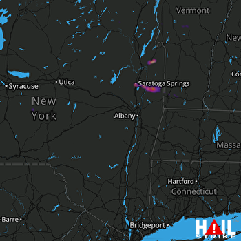 ALBANY (KENX) RADAR
States Impacted By Hail On July 10, 2025
New York
·
Vermont
Counties Impacted By Hail On July 10, 2025
Chenango, NY
·
Clinton, NY
·
Essex, NY
·
Franklin, NY
·
Greene, NY
·
Madison, NY
·
Saratoga, NY
·
St. Lawrence, NY
·
Sullivan, NY
·
Ulster, NY
·
Warren, NY
·
Washington, NY
·
Wayne, NY
·
Addison, VT
·
Bennington, VT
·
Chittenden, VT
·
Grand Isle, VT
·
Rutland, VT
·
Windsor, VT
Cities Impacted By Hail On July 10, 2025
Cambridge, NY
·
Colton, NY
·
Elizabethtown, NY
·
Fort Ann, NY
·
Greenwich, NY
·
Hannawa Falls, NY
·
Redford, NY
·
Saratoga Springs, NY
·
Savannah, NY
·
South Fallsburg, NY
·
South Shaftsbury, VT
Zip Codes Impacted By Hail On July 10, 2025
5257
·
5262
·
5350
·
5363
·
5443
·
5456
·
5472
·
5491
·
5737
·
5748
·
5761
·
5762
·
5767
·
5770
·
5775
·
5776
·
5778
·
12028
·
12057
·
12094
·
12154
·
12170
·
12185
·
12496
·
12733
·
12740
·
12779
·
12789
·
12816
·
12827
·
12831
·
12832
·
12833
·
12834
·
12839
·
12851
·
12852
·
12853
·
12866
·
12871
·
12887
·
12911
·
12913
·
12932
·
12939
·
12941
·
12962
·
12964
·
12970
·
12972
·
12975
·
12976
·
12980
·
12981
·
12983
·
12985
·
12987
·
12993
·
12997
·
13072
·
13146
·
13332
·
13334
·
13464
·
13617
·
13625
·
13672
·
13676
·
13687
·
14433
·
5201
·
5473
·
12918
·
12942
·
12944
·
12945
·
12946

