This weather event on July 10, 2025 includes:
4 states
40 counties,
71 cities,
and 182 zip codes.
There were 119 total properties that were impacted and have possible damage.
States Impacted By Hail On July 10, 2025
Iowa
·
Kansas
·
Missouri
·
Nebraska
Counties Impacted By Hail On July 10, 2025
Fremont, IA
·
Mills, IA
·
Montgomery, IA
·
Page, IA
·
Taylor, IA
·
Atchison, KS
·
Douglas, KS
·
Franklin, KS
·
Jewell, KS
·
Leavenworth, KS
·
Marshall, KS
·
Washington, KS
·
Andrew, MO
·
Atchison, MO
·
Buchanan, MO
·
DeKalb, MO
·
Gentry, MO
·
Holt, MO
·
Nodaway, MO
·
Platte, MO
·
Worth, MO
·
Adams, NE
·
Cass, NE
·
Clay, NE
·
Fillmore, NE
·
Gage, NE
·
Jefferson, NE
·
Johnson, NE
·
Lancaster, NE
·
Nemaha, NE
·
Nuckolls, NE
·
Otoe, NE
·
Richardson, NE
·
Saline, NE
·
Sarpy, NE
·
Saunders, NE
·
Seward, NE
·
Thayer, NE
·
Webster, NE
·
York, NE
Cities Impacted By Hail On July 10, 2025
Albany, MO
·
Alexandria, NE
·
Auburn, NE
·
Bartlett, IA
·
Beatrice, NE
·
Belvidere, NE
·
Bennet, NE
·
Big Lake, MO
·
Burlington Junction, MO
·
Burr, NE
·
Burr Oak, KS
·
Cedar Creek, NE
·
Ceresco, NE
·
Clatonia, NE
·
Cook, NE
·
Cortland, NE
·
Cowles, NE
·
Crete, NE
·
Davenport, NE
·
Davey, NE
·
Dearborn, MO
·
Deshler, NE
·
Deweese, NE
·
Edgar, NE
·
Essex, IA
·
Exeter, NE
·
Fairbury, NE
·
Fairfax, MO
·
Fairmont, NE
·
Fillmore, MO
·
Fortescue, MO
·
Geneva, NE
·
Gilead, NE
·
Glenwood, IA
·
Graham, MO
·
Greenwood, NE
·
Hallam, NE
·
Harbine, NE
·
Hastings, IA
·
Hebron, NE
·
Iatan, MO
·
Irena, MO
·
Jansen, NE
·
Johnson, NE
·
Lansing, KS
·
La Platte, NE
·
Louisville, NE
·
Maitland, MO
·
McCool Junction, NE
·
Murray, NE
·
Nebraska City, NE
·
Oketo, KS
·
Ong, NE
·
Ottawa, KS
·
Pacific Junction, IA
·
Phelps City, MO
·
Plattsmouth, NE
·
Plymouth, NE
·
Randolph, IA
·
Red Cloud, NE
·
Rock Port, MO
·
Seward, NE
·
Shickley, NE
·
Springfield, NE
·
Staplehurst, NE
·
St. Joseph, MO
·
Tabor, IA
·
Tonganoxie, KS
·
Waverly, NE
·
Wilber, NE
·
York, NE
Zip Codes Impacted By Hail On July 10, 2025
50833
·
50848
·
51533
·
51534
·
51540
·
51551
·
51561
·
51566
·
51601
·
51632
·
51638
·
51639
·
51640
·
51645
·
51646
·
51648
·
51649
·
51650
·
51653
·
51654
·
64098
·
64402
·
64423
·
64428
·
64429
·
64431
·
64436
·
64437
·
64439
·
64440
·
64441
·
64445
·
64446
·
64448
·
64449
·
64451
·
64453
·
64455
·
64456
·
64461
·
64466
·
64469
·
64470
·
64473
·
64474
·
64482
·
64484
·
64485
·
64486
·
64487
·
64491
·
64496
·
64498
·
64499
·
64504
·
64505
·
64507
·
66002
·
66007
·
66025
·
66048
·
66067
·
66078
·
66086
·
66092
·
66095
·
66406
·
66412
·
66427
·
66508
·
66936
·
66941
·
66945
·
66956
·
67430
·
68003
·
68016
·
68017
·
68028
·
68037
·
68046
·
68048
·
68059
·
68065
·
68123
·
68133
·
68301
·
68303
·
68305
·
68310
·
68314
·
68315
·
68317
·
68320
·
68321
·
68322
·
68324
·
68326
·
68328
·
68329
·
68331
·
68333
·
68335
·
68336
·
68338
·
68340
·
68343
·
68346
·
68351
·
68352
·
68354
·
68355
·
68357
·
68359
·
68361
·
68362
·
68365
·
68366
·
68368
·
68370
·
68372
·
68401
·
68403
·
68404
·
68405
·
68406
·
68407
·
68409
·
68410
·
68413
·
68415
·
68417
·
68421
·
68422
·
68424
·
68428
·
68430
·
68431
·
68434
·
68436
·
68439
·
68443
·
68444
·
68445
·
68446
·
68450
·
68452
·
68453
·
68455
·
68456
·
68460
·
68462
·
68463
·
68464
·
68465
·
68467
·
68514
·
68527
·
68930
·
68933
·
68934
·
68935
·
68938
·
68941
·
68944
·
68957
·
68970
·
68975
·
68978
·
68979
·
68942
·
68517
·
68378
·
68377
·
68358
·
68341
·
66518
·
66052
·
64503
·
51652
·
51631
·
51503
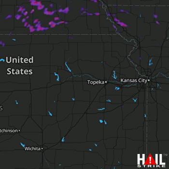 TOPEKA (KTWX) RADAR

