This weather event on July 6, 2025 includes:
4 states
26 counties,
14 cities,
and 62 zip codes.
There were 731 total properties that were impacted and have possible damage.
States Impacted By Hail On July 6, 2025
Iowa
·
Kansas
·
Missouri
·
Nebraska
Counties Impacted By Hail On July 6, 2025
Adams, IA
·
Page, IA
·
Ringgold, IA
·
Taylor, IA
·
Doniphan, KS
·
Republic, KS
·
Washington, KS
·
Andrew, MO
·
Holt, MO
·
Nodaway, MO
·
Boone, NE
·
Butler, NE
·
Gage, NE
·
Garfield, NE
·
Greeley, NE
·
Hamilton, NE
·
Jefferson, NE
·
Lancaster, NE
·
Merrick, NE
·
Nance, NE
·
Platte, NE
·
Polk, NE
·
Saline, NE
·
Thayer, NE
·
Valley, NE
·
Wheeler, NE
Cities Impacted By Hail On July 6, 2025
Cedar Rapids, NE
·
Cornlea, NE
·
De Witt, NE
·
Fairbury, NE
·
Fullerton, NE
·
Garrison, NE
·
Genoa, NE
·
Mahaska, KS
·
Maryville, MO
·
Plymouth, NE
·
Primrose, NE
·
Rising City, NE
·
Silver Creek, NE
·
Wathena, KS
Zip Codes Impacted By Hail On July 6, 2025
50840
·
50851
·
51632
·
64421
·
64423
·
64427
·
64449
·
64455
·
64468
·
64473
·
64483
·
64485
·
64487
·
66087
·
66090
·
66940
·
66944
·
66946
·
66955
·
66958
·
66960
·
66968
·
68310
·
68333
·
68341
·
68350
·
68352
·
68375
·
68377
·
68402
·
68424
·
68465
·
68601
·
68620
·
68623
·
68624
·
68626
·
68628
·
68632
·
68635
·
68637
·
68638
·
68640
·
68642
·
68647
·
68651
·
68655
·
68658
·
68660
·
68662
·
68663
·
68665
·
68669
·
68818
·
68823
·
68841
·
68842
·
68862
·
68875
·
68644
·
68627
·
50845
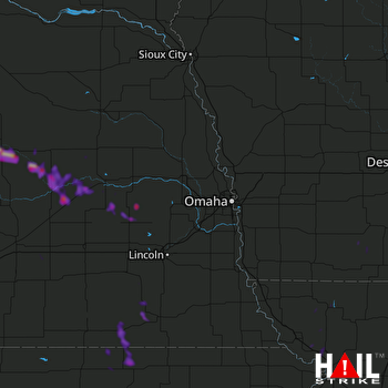 OMAHA (KOAX) RADAR

