This weather event on June 17, 2025 includes:
3 states
17 counties,
25 cities,
and 45 zip codes.
There were 3392 total properties that were impacted and have possible damage.
States Impacted By Hail On June 17, 2025
Illinois
·
Indiana
·
Michigan
Counties Impacted By Hail On June 17, 2025
Cook, IL
·
Grundy, IL
·
Kane, IL
·
Kankakee, IL
·
Lake, IL
·
Livingston, IL
·
Will, IL
·
Elkhart, IN
·
Hamilton, IN
·
Howard, IN
·
LaGrange, IN
·
Steuben, IN
·
St. Joseph, IN
·
Tipton, IN
·
Branch, MI
·
Cass, MI
·
St. Joseph, MI
Cities Impacted By Hail On June 17, 2025
Angola, IN
·
Braceville, IL
·
Braidwood, IL
·
Carbon Hill, IL
·
Carmel, IN
·
Coal City, IL
·
Colon, MI
·
Constantine, MI
·
Diamond, IL
·
Dwight, IL
·
Edwardsburg, MI
·
Fishers, IN
·
Granger, IN
·
Highland Park, IL
·
Lakewood Shores, IL
·
Mazon, IL
·
Mishawaka, IN
·
Noblesville, IN
·
Northbrook, IL
·
Orland, IN
·
Prestbury, IL
·
Sharpsville, IN
·
Sturgis, MI
·
Sugar Grove, IL
·
Wilmington, IL
Zip Codes Impacted By Hail On June 17, 2025
46033
·
46038
·
46062
·
46068
·
46076
·
46507
·
46514
·
46530
·
46540
·
46545
·
46561
·
46565
·
46703
·
46737
·
46746
·
46761
·
46776
·
46902
·
46936
·
49030
·
49040
·
49042
·
49061
·
49067
·
49091
·
49093
·
49099
·
49112
·
49120
·
60035
·
60062
·
60408
·
60416
·
60420
·
60424
·
60442
·
60444
·
60450
·
60479
·
60481
·
60506
·
60554
·
60935
·
60460
·
46060
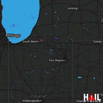 FORT WAYNE (KIWX) RADAR

