This weather event on June 12, 2025 includes:
3 states
23 counties,
11 cities,
and 50 zip codes.
There were total properties that were impacted and have possible damage.
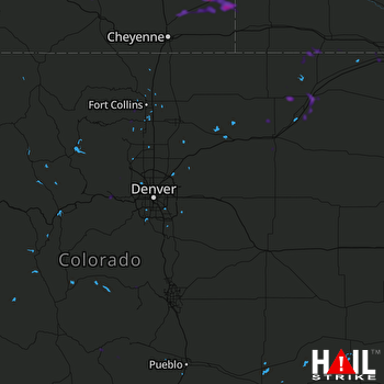 DENVER (KFTG) RADAR
States Impacted By Hail On June 12, 2025
Colorado
·
Nebraska
·
Wyoming
Counties Impacted By Hail On June 12, 2025
Boulder, CO
·
Clear Creek, CO
·
Fremont, CO
·
Gilpin, CO
·
Jefferson, CO
·
Larimer, CO
·
Logan, CO
·
Morgan, CO
·
Phillips, CO
·
Sedgwick, CO
·
Teller, CO
·
Washington, CO
·
Weld, CO
·
Banner, NE
·
Chase, NE
·
Cheyenne, NE
·
Deuel, NE
·
Kimball, NE
·
Scotts Bluff, NE
·
Albany, WY
·
Goshen, WY
·
Laramie, WY
·
Platte, WY
Cities Impacted By Hail On June 12, 2025
Albin, WY
·
Central City, CO
·
Chugwater, WY
·
Coal Creek, CO
·
Divide, CO
·
Idaho Springs, CO
·
Lorenzo, NE
·
Loveland, CO
·
Peetz, CO
·
Slater, WY
·
Sterling, CO
Zip Codes Impacted By Hail On June 12, 2025
69023
·
69128
·
69129
·
69149
·
69162
·
69345
·
69352
·
80302
·
80403
·
80422
·
80427
·
80439
·
80452
·
80466
·
80515
·
80526
·
80537
·
80538
·
80701
·
80720
·
80721
·
80722
·
80723
·
80726
·
80728
·
80733
·
80734
·
80737
·
80741
·
80742
·
80744
·
80745
·
80747
·
80750
·
80751
·
80754
·
80814
·
81223
·
82009
·
82050
·
82051
·
82053
·
82072
·
82081
·
82082
·
82201
·
82210
·
82217
·
82221
·
82244

