This weather event on June 11, 2025 includes:
4 states
21 counties,
26 cities,
and 73 zip codes.
There were 379 total properties that were impacted and have possible damage.
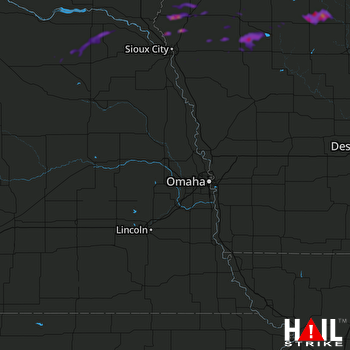 OMAHA (KOAX) RADAR
States Impacted By Hail On June 11, 2025
Iowa
·
Missouri
·
Nebraska
·
South Dakota
Counties Impacted By Hail On June 11, 2025
Boone, IA
·
Buena Vista, IA
·
Cherokee, IA
·
Clay, IA
·
Greene, IA
·
Humboldt, IA
·
Ida, IA
·
O'Brien, IA
·
Plymouth, IA
·
Pocahontas, IA
·
Sac, IA
·
Sioux, IA
·
Webster, IA
·
Woodbury, IA
·
Nodaway, MO
·
Antelope, NE
·
Cedar, NE
·
Knox, NE
·
Pierce, NE
·
Thurston, NE
·
Union, SD
Cities Impacted By Hail On June 11, 2025
Alta, IA
·
Alton, IA
·
Anthon, IA
·
Bradgate, IA
·
Brunsville, IA
·
Craig, IA
·
Creighton, NE
·
Cushing, IA
·
Duncombe, IA
·
Everly, IA
·
Galva, IA
·
Hartington, NE
·
Havelock, IA
·
Holstein, IA
·
Kingsley, IA
·
Le Mars, IA
·
Meriden, IA
·
Orange City, IA
·
Oyens, IA
·
Pocahontas, IA
·
Remsen, IA
·
Rolfe, IA
·
Sioux Center, IA
·
Storm Lake, IA
·
Washta, IA
·
Wausa, NE
Zip Codes Impacted By Hail On June 11, 2025
50107
·
50212
·
50217
·
50501
·
50510
·
50516
·
50520
·
50541
·
50546
·
50554
·
50568
·
50570
·
50574
·
50581
·
50582
·
50588
·
50594
·
51001
·
51002
·
51003
·
51004
·
51007
·
51008
·
51012
·
51014
·
51016
·
51018
·
51020
·
51023
·
51024
·
51025
·
51027
·
51028
·
51029
·
51031
·
51035
·
51036
·
51037
·
51038
·
51039
·
51041
·
51047
·
51049
·
51050
·
51053
·
51054
·
51055
·
51058
·
51061
·
51062
·
51109
·
51201
·
51234
·
51239
·
51245
·
51250
·
51338
·
51346
·
51445
·
57038
·
64468
·
68071
·
68718
·
68729
·
68736
·
68739
·
68765
·
68769
·
68786
·
68792
·
50064
·
50532
·
51005

