This weather event on June 6, 2025 includes:
3 states
13 counties,
17 cities,
and 83 zip codes.
There were 721 total properties that were impacted and have possible damage.
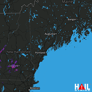 PORTLAND (KGYX) RADAR
States Impacted By Hail On June 6, 2025
Massachusetts
·
New Hampshire
·
Vermont
Counties Impacted By Hail On June 6, 2025
Franklin, MA
·
Belknap, NH
·
Carroll, NH
·
Cheshire, NH
·
Coos, NH
·
Grafton, NH
·
Hillsborough, NH
·
Merrimack, NH
·
Rockingham, NH
·
Sullivan, NH
·
Orange, VT
·
Windham, VT
·
Windsor, VT
Cities Impacted By Hail On June 6, 2025
Antrim, NH
·
Ascutney, VT
·
Cavendish, VT
·
Concord, NH
·
Contoocook, NH
·
Derry, NH
·
Franklin, NH
·
Hancock, NH
·
Henniker, NH
·
Hillsborough, NH
·
Meredith, NH
·
North Haverhill, NH
·
North Walpole, NH
·
Orange, MA
·
Proctorsville, VT
·
Warner, NH
·
Woodstock, VT
Zip Codes Impacted By Hail On June 6, 2025
1360
·
1378
·
3038
·
3043
·
3046
·
3047
·
3070
·
3216
·
3223
·
3226
·
3229
·
3230
·
3233
·
3235
·
3242
·
3244
·
3245
·
3254
·
3257
·
3259
·
3260
·
3264
·
3268
·
3273
·
3275
·
3276
·
3278
·
3280
·
3281
·
3287
·
3301
·
3303
·
3440
·
3448
·
3449
·
3456
·
3458
·
3464
·
3583
·
3588
·
3593
·
3602
·
3603
·
3605
·
3608
·
3609
·
3752
·
3774
·
3780
·
5001
·
5037
·
5045
·
5053
·
5058
·
5059
·
5062
·
5065
·
5067
·
5070
·
5071
·
5079
·
5083
·
5084
·
5089
·
5091
·
5101
·
5141
·
5142
·
5143
·
5146
·
5149
·
5150
·
5151
·
5153
·
5156
·
5345
·
5353
·
5359
·
5075
·
5055
·
3253
·
3221
·
1364

