This weather event on May 31, 2025 includes:
3 states
21 counties,
22 cities,
and 92 zip codes.
There were 3368 total properties that were impacted and have possible damage.
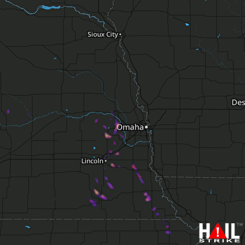 OMAHA (KOAX) RADAR
States Impacted By Hail On May 31, 2025
Kansas
·
Missouri
·
Nebraska
Counties Impacted By Hail On May 31, 2025
Atchison, KS
·
Brown, KS
·
Doniphan, KS
·
Buchanan, MO
·
Platte, MO
·
Boone, NE
·
Cass, NE
·
Dodge, NE
·
Douglas, NE
·
Gage, NE
·
Greeley, NE
·
Jefferson, NE
·
Johnson, NE
·
Lancaster, NE
·
Nance, NE
·
Nemaha, NE
·
Otoe, NE
·
Richardson, NE
·
Saline, NE
·
Sarpy, NE
·
Saunders, NE
Cities Impacted By Hail On May 31, 2025
Atchison, KS
·
Beatrice, NE
·
Dawson, NE
·
Fremont, NE
·
Hamlin, KS
·
Hiawatha, KS
·
Inglewood, NE
·
Leshara, NE
·
Lewis and Clark Village, MO
·
Lincoln, NE
·
Lorton, NE
·
Malmo, NE
·
Mead, NE
·
Plymouth, NE
·
Rushville, MO
·
Salem, NE
·
Talmage, NE
·
Walton, NE
·
Wann, NE
·
Waverly, NE
·
Yankee Hill, NE
·
Yutan, NE
Zip Codes Impacted By Hail On May 31, 2025
64098
·
64440
·
64484
·
66002
·
66041
·
66434
·
66515
·
68003
·
68015
·
68017
·
68018
·
68025
·
68028
·
68031
·
68033
·
68036
·
68040
·
68050
·
68064
·
68066
·
68070
·
68073
·
68301
·
68304
·
68307
·
68310
·
68317
·
68320
·
68324
·
68328
·
68329
·
68331
·
68333
·
68336
·
68337
·
68341
·
68346
·
68347
·
68349
·
68355
·
68357
·
68358
·
68366
·
68368
·
68372
·
68376
·
68377
·
68378
·
68382
·
68404
·
68417
·
68418
·
68422
·
68424
·
68430
·
68433
·
68442
·
68443
·
68446
·
68448
·
68457
·
68461
·
68462
·
68502
·
68503
·
68504
·
68506
·
68507
·
68508
·
68510
·
68512
·
68514
·
68516
·
68517
·
68520
·
68521
·
68522
·
68523
·
68526
·
68527
·
68528
·
68621
·
68623
·
68627
·
68638
·
68648
·
68842
·
68864
·
68882
·
68041
·
68305
·
68454

