This weather event on May 31, 2025 includes:
5 states
13 counties,
38 cities,
and 69 zip codes.
There were 21308 total properties that were impacted and have possible damage.
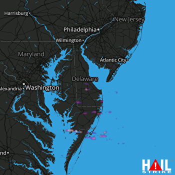 DOVER AFB (KDOX) RADAR
States Impacted By Hail On May 31, 2025
Delaware
·
Maryland
·
New Jersey
·
Pennsylvania
·
Virginia
Counties Impacted By Hail On May 31, 2025
Kent, DE
·
Sussex, DE
·
Dorchester, MD
·
Prince George's, MD
·
Somerset, MD
·
Wicomico, MD
·
Worcester, MD
·
Cape May, NJ
·
Cumberland, NJ
·
Salem, NJ
·
Montgomery, PA
·
Accomack, VA
·
Northampton, VA
Cities Impacted By Hail On May 31, 2025
Beltsville, MD
·
Berlin, MD
·
Bethany Beach, DE
·
Bethel, DE
·
Blades, DE
·
Chincoteague, VA
·
Crisfield, MD
·
Diamond Beach, NJ
·
Eden, MD
·
Ellendale, DE
·
Galestown, MD
·
Greenbelt, MD
·
Harrington, DE
·
Horntown, VA
·
Houston, DE
·
Laurel, DE
·
Milford, DE
·
Millville, DE
·
Millville, NJ
·
Milton, DE
·
Norristown, PA
·
Ocean City, MD
·
Ocean View, DE
·
Pocomoke City, MD
·
Powellville, MD
·
Salisbury, MD
·
Sanford, VA
·
Seaford, DE
·
Sharptown, MD
·
Smith Island, MD
·
Stockton, MD
·
Trooper, PA
·
Tyaskin, MD
·
Wattsville, VA
·
West Ocean City, MD
·
Whaleyville, MD
·
Wildwood Crest, NJ
·
Woodstown, NJ
Zip Codes Impacted By Hail On May 31, 2025
8067
·
8069
·
8098
·
8230
·
8270
·
8332
·
19401
·
19403
·
19422
·
19901
·
19930
·
19931
·
19939
·
19941
·
19945
·
19947
·
19950
·
19951
·
19952
·
19954
·
19956
·
19958
·
19960
·
19963
·
19966
·
19967
·
19968
·
19970
·
19973
·
19977
·
20705
·
20770
·
21659
·
21804
·
21810
·
21811
·
21817
·
21822
·
21824
·
21829
·
21837
·
21838
·
21842
·
21849
·
21850
·
21851
·
21853
·
21856
·
21861
·
21864
·
21865
·
21872
·
21874
·
23302
·
23336
·
23337
·
23356
·
23359
·
23395
·
23398
·
23407
·
23415
·
23416
·
23442
·
23488
·
23350
·
21862
·
19940
·
8260

