This weather event on May 28, 2025 includes:
3 states
28 counties,
15 cities,
and 68 zip codes.
There were total properties that were impacted and have possible damage.
States Impacted By Hail On May 28, 2025
Alabama
·
Florida
·
Georgia
Counties Impacted By Hail On May 28, 2025
Blount, AL
·
Coffee, AL
·
Conecuh, AL
·
Coosa, AL
·
Covington, AL
·
Escambia, AL
·
Fayette, AL
·
Geneva, AL
·
Jefferson, AL
·
Tuscaloosa, AL
·
Walker, AL
·
Okaloosa, FL
·
Santa Rosa, FL
·
Walton, FL
·
Washington, FL
·
Colquitt, GA
·
Crawford, GA
·
Crisp, GA
·
Dooly, GA
·
Lee, GA
·
Macon, GA
·
Marion, GA
·
Monroe, GA
·
Schley, GA
·
Sumter, GA
·
Taylor, GA
·
Upson, GA
·
Wilcox, GA
Cities Impacted By Hail On May 28, 2025
Butler, GA
·
Cordele, GA
·
Graysville, AL
·
Harold, FL
·
Ideal, GA
·
Munson, FL
·
Niceville, FL
·
Reynolds, GA
·
Roeville, FL
·
Salem, GA
·
Sipsey, AL
·
Springhill, FL
·
Stewartville, AL
·
Valparaiso, FL
·
Weogufka, AL
Zip Codes Impacted By Hail On May 28, 2025
31001
·
31006
·
31015
·
31016
·
31029
·
31041
·
31058
·
31066
·
31072
·
31076
·
31078
·
31081
·
31092
·
31220
·
31712
·
31719
·
31735
·
31743
·
31756
·
31763
·
31764
·
31768
·
31780
·
31803
·
31806
·
32427
·
32433
·
32435
·
32455
·
32462
·
32531
·
32539
·
32542
·
32564
·
32565
·
32567
·
32570
·
32578
·
32580
·
32583
·
35023
·
35033
·
35062
·
35063
·
35073
·
35079
·
35130
·
35139
·
35151
·
35180
·
35183
·
35446
·
35452
·
35475
·
35504
·
35546
·
35550
·
35580
·
35584
·
36420
·
36426
·
36441
·
36442
·
36453
·
36467
·
36475
·
36483
·
36502
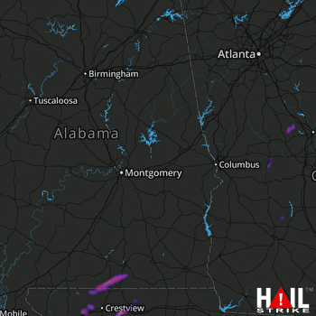 MONTGOMERY (KMXX) RADAR

