This weather event on May 28, 2025 includes:
2 states
15 counties,
17 cities,
and 60 zip codes.
There were 3418 total properties that were impacted and have possible damage.
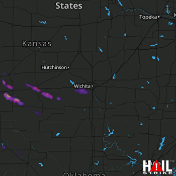 WICHITA (KICT) RADAR
States Impacted By Hail On May 28, 2025
Kansas
·
Oklahoma
Counties Impacted By Hail On May 28, 2025
Barber, KS
·
Comanche, KS
·
Edwards, KS
·
Ford, KS
·
Harper, KS
·
Hodgeman, KS
·
Kingman, KS
·
Kiowa, KS
·
Pawnee, KS
·
Pratt, KS
·
Sedgwick, KS
·
Stafford, KS
·
Sumner, KS
·
Ellis, OK
·
Woodward, OK
Cities Impacted By Hail On May 28, 2025
Belpre, KS
·
Bucklin, KS
·
Cheney, KS
·
Clearwater, KS
·
Dodge City, KS
·
Ford, KS
·
Garden Plain, KS
·
Goddard, KS
·
Haysville, KS
·
Milton, KS
·
Mooreland, OK
·
Mullinville, KS
·
Pratt, KS
·
Spivey, KS
·
Wellington, KS
·
Wichita, KS
·
Woodward, OK
Zip Codes Impacted By Hail On May 28, 2025
67004
·
67021
·
67025
·
67026
·
67028
·
67029
·
67031
·
67035
·
67037
·
67050
·
67052
·
67054
·
67057
·
67058
·
67059
·
67060
·
67065
·
67066
·
67068
·
67070
·
67071
·
67104
·
67106
·
67109
·
67111
·
67112
·
67118
·
67120
·
67124
·
67134
·
67142
·
67143
·
67149
·
67152
·
67155
·
67159
·
67209
·
67215
·
67216
·
67217
·
67227
·
67235
·
67519
·
67523
·
67547
·
67552
·
67557
·
67563
·
67576
·
67801
·
67834
·
67842
·
67854
·
67876
·
67882
·
73801
·
73840
·
73841
·
73852
·
73853

