This weather event on May 28, 2025 includes:
3 states
30 counties,
16 cities,
and 62 zip codes.
There were 1075 total properties that were impacted and have possible damage.
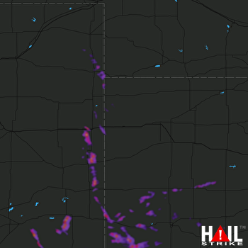 GOODLAND (KGLD) RADAR
States Impacted By Hail On May 28, 2025
Colorado
·
Kansas
·
Nebraska
Counties Impacted By Hail On May 28, 2025
Baca, CO
·
Bent, CO
·
Cheyenne, CO
·
Kiowa, CO
·
Kit Carson, CO
·
Las Animas, CO
·
Otero, CO
·
Phillips, CO
·
Prowers, CO
·
Yuma, CO
·
Cheyenne, KS
·
Finney, KS
·
Ford, KS
·
Grant, KS
·
Gray, KS
·
Hamilton, KS
·
Haskell, KS
·
Hodgeman, KS
·
Kearny, KS
·
Lane, KS
·
Morton, KS
·
Ness, KS
·
Scott, KS
·
Seward, KS
·
Sherman, KS
·
Stanton, KS
·
Stevens, KS
·
Wichita, KS
·
Chase, NE
·
Dundy, NE
Cities Impacted By Hail On May 28, 2025
Bethune, CO
·
Burlington, CO
·
Coolidge, KS
·
Dighton, KS
·
Dodge City, KS
·
Johnson City, KS
·
Laird, CO
·
Lakin, KS
·
Lamar, CO
·
Manter, KS
·
Satanta, KS
·
Scott City, KS
·
Syracuse, KS
·
Ulysses, KS
·
Vilas, CO
·
Walsh, CO
Zip Codes Impacted By Hail On May 28, 2025
67515
·
67518
·
67560
·
67572
·
67584
·
67735
·
67741
·
67756
·
67801
·
67835
·
67836
·
67838
·
67839
·
67846
·
67850
·
67851
·
67853
·
67854
·
67855
·
67857
·
67860
·
67861
·
67862
·
67863
·
67870
·
67871
·
67876
·
67877
·
67878
·
67880
·
67882
·
67952
·
67953
·
67954
·
69030
·
80731
·
80734
·
80735
·
80758
·
80759
·
80802
·
80807
·
80810
·
80815
·
80821
·
80862
·
81041
·
81044
·
81047
·
81049
·
81050
·
81052
·
81054
·
81057
·
81071
·
81073
·
81084
·
81087
·
81090
·
81092
·
80805
·
69023

