This weather event on May 28, 2025 includes:
1 states
18 counties,
24 cities,
and 89 zip codes.
There were 144145 total properties that were impacted and have possible damage.
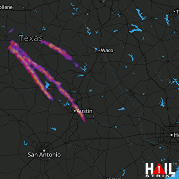 KILLEEN (KGRK) RADAR
States Impacted By Hail On May 28, 2025
Texas
Counties Impacted By Hail On May 28, 2025
Bastrop, TX
·
Bell, TX
·
Blanco, TX
·
Bosque, TX
·
Brown, TX
·
Burnet, TX
·
Coleman, TX
·
Comanche, TX
·
Coryell, TX
·
Erath, TX
·
Hamilton, TX
·
Lampasas, TX
·
Llano, TX
·
McCulloch, TX
·
Mills, TX
·
San Saba, TX
·
Travis, TX
·
Williamson, TX
Cities Impacted By Hail On May 28, 2025
Bangs, TX
·
Bertram, TX
·
Brushy Creek, TX
·
Buchanan Dam, TX
·
Burnet, TX
·
Cedar Park, TX
·
Cottonwood Shores, TX
·
Garfield, TX
·
Granite Shoals, TX
·
Highland Haven, TX
·
Hornsby Bend, TX
·
Horseshoe Bay, TX
·
Jonestown, TX
·
Kingsland, TX
·
Leander, TX
·
Liberty Hill, TX
·
Marble Falls, TX
·
Meadowlakes, TX
·
Richland Springs, TX
·
San Saba, TX
·
Santa Anna, TX
·
Sunrise Beach Village, TX
·
Volente, TX
·
Wyldwood, TX
Zip Codes Impacted By Hail On May 28, 2025
76442
·
76446
·
76452
·
76455
·
76457
·
76513
·
76525
·
76528
·
76531
·
76538
·
76543
·
76550
·
76565
·
76566
·
76649
·
76671
·
76823
·
76824
·
76827
·
76828
·
76832
·
76834
·
76844
·
76845
·
76853
·
76857
·
76864
·
76870
·
76871
·
76872
·
76873
·
76877
·
76878
·
76885
·
78602
·
78605
·
78607
·
78609
·
78611
·
78612
·
78613
·
78616
·
78617
·
78628
·
78639
·
78641
·
78642
·
78643
·
78645
·
78653
·
78654
·
78657
·
78669
·
78672
·
78681
·
78701
·
78702
·
78703
·
78705
·
78717
·
78719
·
78721
·
78722
·
78723
·
78724
·
78725
·
78726
·
78727
·
78729
·
78730
·
78731
·
78732
·
78741
·
78742
·
78744
·
78746
·
78750
·
78751
·
78752
·
78753
·
78754
·
78756
·
78757
·
78758
·
78759
·
78957
·
78712
·
78662
·
76801

