This weather event on May 28, 2025 includes:
1 states
19 counties,
17 cities,
and 68 zip codes.
There were 3353 total properties that were impacted and have possible damage.
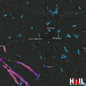 DALLAS/FTW (KFWS) RADAR
States Impacted By Hail On May 28, 2025
Texas
Counties Impacted By Hail On May 28, 2025
Bell, TX
·
Bosque, TX
·
Brown, TX
·
Burnet, TX
·
Callahan, TX
·
Coleman, TX
·
Comanche, TX
·
Coryell, TX
·
Hamilton, TX
·
Hill, TX
·
Lampasas, TX
·
Llano, TX
·
McCulloch, TX
·
Mills, TX
·
San Saba, TX
·
Shackelford, TX
·
Stephens, TX
·
Travis, TX
·
Williamson, TX
Cities Impacted By Hail On May 28, 2025
Belton, TX
·
Bertram, TX
·
Brushy Creek, TX
·
Buchanan Dam, TX
·
Burnet, TX
·
Cedar Park, TX
·
Coleman, TX
·
Comanche, TX
·
Kingsland, TX
·
Leander, TX
·
Liberty Hill, TX
·
Nolanville, TX
·
Putnam, TX
·
Richland Springs, TX
·
San Saba, TX
·
Santa Anna, TX
·
Temple, TX
Zip Codes Impacted By Hail On May 28, 2025
76437
·
76442
·
76443
·
76444
·
76446
·
76452
·
76455
·
76457
·
76469
·
76502
·
76513
·
76525
·
76528
·
76531
·
76534
·
76538
·
76543
·
76544
·
76550
·
76554
·
76559
·
76565
·
76566
·
76571
·
76627
·
76636
·
76649
·
76665
·
76671
·
76690
·
76801
·
76802
·
76823
·
76824
·
76827
·
76828
·
76832
·
76834
·
76844
·
76845
·
76853
·
76857
·
76864
·
76870
·
76872
·
76873
·
76877
·
76878
·
76882
·
76884
·
76885
·
78605
·
78607
·
78609
·
78611
·
78613
·
78639
·
78641
·
78642
·
78643
·
78654
·
78672
·
78681
·
78717
·
79504
·
76890
·
76871
·
76464

