This weather event on May 22, 2025 includes:
2 states
17 counties,
37 cities,
and 55 zip codes.
There were 6712 total properties that were impacted and have possible damage.
States Impacted By Hail On May 22, 2025
Maryland
·
Virginia
Counties Impacted By Hail On May 22, 2025
Anne Arundel, MD
·
Baltimore, MD
·
Baltimore, MD
·
Carroll, MD
·
Dorchester, MD
·
Montgomery, MD
·
Prince George's, MD
·
Talbot, MD
·
Fairfax, VA
·
Gloucester, VA
·
James City, VA
·
King William, VA
·
Loudoun, VA
·
New Kent, VA
·
Northumberland, VA
·
Westmoreland, VA
·
York, VA
Cities Impacted By Hail On May 22, 2025
Algonquin, MD
·
Andrews AFB, MD
·
Arnold, MD
·
Ashburn, VA
·
Baltimore, MD
·
Brock Hall, MD
·
Cambridge, MD
·
Camp Springs, MD
·
Cascades, VA
·
Clinton, MD
·
Crofton, MD
·
Croom, MD
·
Darnestown, MD
·
Deale, MD
·
Dulles Town Center, VA
·
East New Market, MD
·
Galesville, MD
·
Great Falls, VA
·
Hampstead, MD
·
Hurlock, MD
·
Lake Shore, MD
·
Marlboro Meadows, MD
·
Marlboro Village, MD
·
Melwood, MD
·
Odenton, MD
·
Oxford, MD
·
Queensland, MD
·
Rosaryville, MD
·
Severna Park, MD
·
Shady Side, MD
·
Sterling, VA
·
Sugarland Run, VA
·
Tilghman Island, MD
·
Trappe, MD
·
Upper Marlboro, MD
·
Westphalia, MD
·
West Point, VA
Zip Codes Impacted By Hail On May 22, 2025
20147
·
20164
·
20165
·
20166
·
20711
·
20733
·
20735
·
20744
·
20748
·
20751
·
20762
·
20764
·
20772
·
20774
·
20778
·
20837
·
20874
·
21012
·
21054
·
21074
·
21102
·
21113
·
21114
·
21120
·
21122
·
21146
·
21157
·
21158
·
21161
·
21205
·
21213
·
21224
·
21601
·
21612
·
21613
·
21631
·
21643
·
21654
·
21659
·
21662
·
21665
·
21671
·
21673
·
21676
·
21776
·
21835
·
22066
·
22435
·
22482
·
22488
·
22511
·
23061
·
23072
·
23181
·
23188
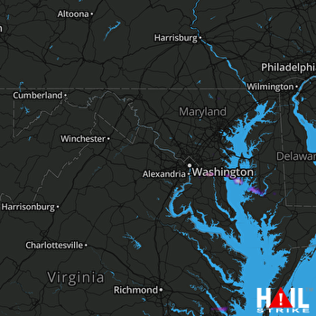 STERLING (KLWX) RADAR

