This weather event on May 21, 2025 includes:
2 states
24 counties,
12 cities,
and 57 zip codes.
There were 11160 total properties that were impacted and have possible damage.
States Impacted By Hail On May 21, 2025
Florida
·
Georgia
Counties Impacted By Hail On May 21, 2025
Baker, FL
·
Columbia, FL
·
Duval, FL
·
Hamilton, FL
·
Jefferson, FL
·
Lafayette, FL
·
Leon, FL
·
Madison, FL
·
Nassau, FL
·
Suwannee, FL
·
Taylor, FL
·
Wakulla, FL
·
Atkinson, GA
·
Berrien, GA
·
Brooks, GA
·
Charlton, GA
·
Clinch, GA
·
Colquitt, GA
·
Cook, GA
·
Echols, GA
·
Lanier, GA
·
Lowndes, GA
·
Thomas, GA
·
Ware, GA
Cities Impacted By Hail On May 21, 2025
Adel, GA
·
Echols County, GA
·
Fargo, GA
·
Jacksonville, FL
·
Lakeland, GA
·
Moody AFB, GA
·
Nashville, GA
·
Nassau Village-Ratliff, FL
·
Ray City, GA
·
Remerton, GA
·
Sparks, GA
·
Valdosta, GA
Zip Codes Impacted By Hail On May 21, 2025
31537
·
31562
·
31601
·
31602
·
31605
·
31606
·
31620
·
31625
·
31630
·
31631
·
31632
·
31634
·
31635
·
31636
·
31638
·
31639
·
31641
·
31642
·
31643
·
31645
·
31647
·
31648
·
31649
·
31699
·
31738
·
31768
·
31778
·
31788
·
32009
·
32011
·
32024
·
32040
·
32046
·
32052
·
32053
·
32059
·
32063
·
32087
·
32096
·
32097
·
32206
·
32208
·
32209
·
32210
·
32211
·
32218
·
32219
·
32220
·
32226
·
32254
·
32256
·
32277
·
32309
·
32336
·
32340
·
32344
·
32350
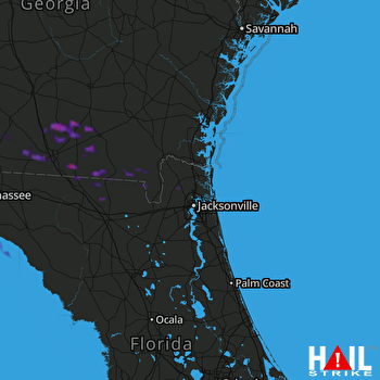 JACKSONVILLE (KJAX) RADAR

