This weather event on May 19, 2025 includes:
3 states
12 counties,
24 cities,
and 49 zip codes.
There were 3960 total properties that were impacted and have possible damage.
States Impacted By Hail On May 19, 2025
Idaho
·
Nevada
·
Utah
Counties Impacted By Hail On May 19, 2025
Cassia, ID
·
Elko, NV
·
Box Elder, UT
·
Cache, UT
·
Davis, UT
·
Morgan, UT
·
Salt Lake, UT
·
Summit, UT
·
Tooele, UT
·
Utah, UT
·
Wasatch, UT
·
Weber, UT
Cities Impacted By Hail On May 19, 2025
Brigham City, UT
·
Copperton, UT
·
Cottonwood Heights, UT
·
Deweyville, UT
·
Elwood, UT
·
Grantsville, UT
·
Heber, UT
·
Herriman, UT
·
Honeyville, UT
·
Marriott-Slaterville, UT
·
Midvale, UT
·
Nibley, UT
·
Ogden, UT
·
Salt Lake City, UT
·
Sandy, UT
·
South Jordan, UT
·
South Salt Lake, UT
·
Taylorsville, UT
·
Tooele, UT
·
Wellsville, UT
·
West Haven, UT
·
West Jordan, UT
·
West Valley City, UT
·
White City, UT
Zip Codes Impacted By Hail On May 19, 2025
83312
·
83342
·
84003
·
84004
·
84006
·
84029
·
84032
·
84044
·
84047
·
84050
·
84055
·
84069
·
84070
·
84071
·
84074
·
84081
·
84083
·
84084
·
84088
·
84092
·
84093
·
84094
·
84095
·
84096
·
84104
·
84108
·
84116
·
84118
·
84119
·
84121
·
84123
·
84302
·
84309
·
84310
·
84314
·
84319
·
84321
·
84324
·
84326
·
84329
·
84336
·
84337
·
84339
·
84401
·
84403
·
84404
·
84414
·
89830
·
84022
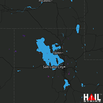 SALT LAKE CTY (KMTX) RADAR

