This weather event on May 17, 2025 includes:
2 states
21 counties,
28 cities,
and 64 zip codes.
There were 34 total properties that were impacted and have possible damage.
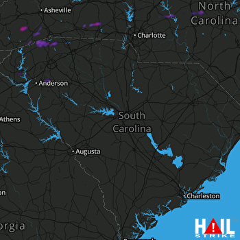 COLUMBIA (KCAE) RADAR
States Impacted By Hail On May 17, 2025
North Carolina
·
South Carolina
Counties Impacted By Hail On May 17, 2025
Cabarrus, NC
·
Cleveland, NC
·
Davidson, NC
·
Gaston, NC
·
Haywood, NC
·
Henderson, NC
·
Jackson, NC
·
Lincoln, NC
·
Mecklenburg, NC
·
Montgomery, NC
·
Moore, NC
·
Randolph, NC
·
Rowan, NC
·
Rutherford, NC
·
Stanly, NC
·
Transylvania, NC
·
Anderson, SC
·
Greenville, SC
·
Oconee, SC
·
Pickens, SC
·
Spartanburg, SC
Cities Impacted By Hail On May 17, 2025
Belton, SC
·
Bostic, NC
·
Brevard, NC
·
Chesnee, SC
·
Clemson, SC
·
Concord, NC
·
Davidson, NC
·
Edneyville, NC
·
Etowah, NC
·
Fallston, NC
·
Fingerville, SC
·
Fruitland, NC
·
Hendersonville, NC
·
Horse Shoe, NC
·
Kannapolis, NC
·
Kingstown, NC
·
Landis, NC
·
Lawndale, NC
·
Lincolnton, NC
·
Mills River, NC
·
Misenheimer, NC
·
Pendleton, SC
·
Polkville, NC
·
Rutherfordton, NC
·
Seagrove, NC
·
Seneca, SC
·
Tigerville, SC
·
Utica, SC
Zip Codes Impacted By Hail On May 17, 2025
27205
·
27208
·
27239
·
27325
·
27341
·
27371
·
28018
·
28021
·
28023
·
28025
·
28033
·
28036
·
28040
·
28043
·
28071
·
28078
·
28081
·
28083
·
28092
·
28109
·
28127
·
28137
·
28138
·
28139
·
28150
·
28708
·
28712
·
28716
·
28718
·
28729
·
28739
·
28742
·
28759
·
28766
·
28768
·
28772
·
28783
·
28790
·
28791
·
28792
·
29322
·
29323
·
29338
·
29349
·
29356
·
29625
·
29627
·
29631
·
29634
·
29635
·
29651
·
29661
·
29669
·
29670
·
29678
·
29687
·
29690
·
29691
·
29693
·
29697
·
29672
·
28090
·
28031
·
27316

