This weather event on May 17, 2025 includes:
3 states
22 counties,
10 cities,
and 53 zip codes.
There were 3071 total properties that were impacted and have possible damage.
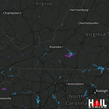 ROANOKE (KFCX) RADAR
States Impacted By Hail On May 17, 2025
North Carolina
·
Virginia
·
West Virginia
Counties Impacted By Hail On May 17, 2025
Alexander, NC
·
Cleveland, NC
·
Iredell, NC
·
Mitchell, NC
·
Wilkes, NC
·
Yadkin, NC
·
Yancey, NC
·
Bedford, VA
·
Bland, VA
·
Charlotte, VA
·
Floyd, VA
·
Franklin, VA
·
Montgomery, VA
·
Pittsylvania, VA
·
Pulaski, VA
·
Russell, VA
·
Scott, VA
·
Smyth, VA
·
Tazewell, VA
·
Washington, VA
·
Wythe, VA
·
Monroe, WV
Cities Impacted By Hail On May 17, 2025
Burnsville, NC
·
Charlotte Court House, VA
·
Henry Fork, VA
·
Kingstown, NC
·
North Shore, VA
·
Penhook, VA
·
Plum Creek, VA
·
Polkville, NC
·
Rocky Mount, VA
·
Union Hall, VA
Zip Codes Impacted By Hail On May 17, 2025
23923
·
23962
·
24065
·
24067
·
24073
·
24091
·
24092
·
24104
·
24121
·
24137
·
24139
·
24151
·
24161
·
24176
·
24184
·
24202
·
24225
·
24236
·
24260
·
24266
·
24280
·
24311
·
24315
·
24318
·
24319
·
24347
·
24354
·
24368
·
24370
·
24377
·
24531
·
24557
·
24566
·
24609
·
24637
·
24651
·
24941
·
28740
·
28777
·
24649
·
24983
·
27018
·
28090
·
28150
·
28625
·
28636
·
28660
·
28665
·
28670
·
28678
·
28681
·
28705
·
28714

