This weather event on May 17, 2025 includes:
4 states
31 counties,
23 cities,
and 70 zip codes.
There were 8191 total properties that were impacted and have possible damage.
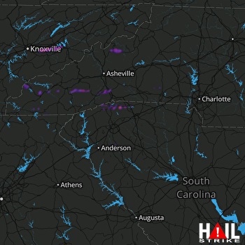 GREER (KGSP) RADAR
States Impacted By Hail On May 17, 2025
North Carolina
·
South Carolina
·
Tennessee
·
Virginia
Counties Impacted By Hail On May 17, 2025
Alexander, NC
·
Clay, NC
·
Cleveland, NC
·
Gaston, NC
·
Graham, NC
·
Haywood, NC
·
Henderson, NC
·
Jackson, NC
·
Lincoln, NC
·
Macon, NC
·
Madison, NC
·
Mitchell, NC
·
Polk, NC
·
Rutherford, NC
·
Swain, NC
·
Transylvania, NC
·
Yancey, NC
·
Anderson, SC
·
Cherokee, SC
·
Greenville, SC
·
Oconee, SC
·
Pickens, SC
·
Spartanburg, SC
·
Blount, TN
·
Cocke, TN
·
Hamblen, TN
·
Jefferson, TN
·
Knox, TN
·
Monroe, TN
·
Sevier, TN
·
Russell, VA
Cities Impacted By Hail On May 17, 2025
Balfour, NC
·
Baneberry, TN
·
Belton, SC
·
Burnsville, NC
·
Campobello, SC
·
Cullowhee, NC
·
Dandridge, TN
·
Edneyville, NC
·
Etowah, NC
·
Fallston, NC
·
Fontana Dam, NC
·
Fruitland, NC
·
Hendersonville, NC
·
Horse Shoe, NC
·
Laurel Park, NC
·
Lawndale, NC
·
Mills River, NC
·
Mountain Home, NC
·
Polkville, NC
·
Seneca, SC
·
Sevierville, TN
·
Tigerville, SC
·
Utica, SC
Zip Codes Impacted By Hail On May 17, 2025
24225
·
24260
·
24266
·
28018
·
28021
·
28033
·
28040
·
28090
·
28092
·
28150
·
28636
·
28681
·
28702
·
28705
·
28707
·
28712
·
28713
·
28714
·
28716
·
28718
·
28723
·
28729
·
28732
·
28733
·
28734
·
28739
·
28740
·
28742
·
28754
·
28759
·
28768
·
28771
·
28773
·
28779
·
28786
·
28789
·
28791
·
28792
·
28904
·
29322
·
29323
·
29330
·
29349
·
29356
·
29627
·
29635
·
29644
·
29651
·
29654
·
29661
·
29669
·
29672
·
29678
·
29687
·
29690
·
29693
·
37354
·
37725
·
37764
·
37820
·
37821
·
37865
·
37871
·
37876
·
37878
·
37885
·
37890
·
37914
·
37920
·
28790

