This weather event on May 13, 2025 includes:
4 states
26 counties,
9 cities,
and 53 zip codes.
There were 536 total properties that were impacted and have possible damage.
States Impacted By Hail On May 13, 2025
North Carolina
·
South Carolina
·
Tennessee
·
Virginia
Counties Impacted By Hail On May 13, 2025
Anson, NC
·
Buncombe, NC
·
Cabarrus, NC
·
Davidson, NC
·
Haywood, NC
·
Jackson, NC
·
Macon, NC
·
Madison, NC
·
Richmond, NC
·
Rowan, NC
·
Stanly, NC
·
Transylvania, NC
·
Union, NC
·
Chesterfield, SC
·
Greenville, SC
·
Kershaw, SC
·
Lancaster, SC
·
Marlboro, SC
·
Oconee, SC
·
Pickens, SC
·
York, SC
·
Blount, TN
·
Cocke, TN
·
Sevier, TN
·
Washington, TN
·
Washington, VA
Cities Impacted By Hail On May 13, 2025
Canton, NC
·
Chesterfield, SC
·
Concord, NC
·
Fort Mill, SC
·
McFarlan, NC
·
Mount Pleasant, NC
·
Oak Grove, TN
·
Salem, SC
·
Spurgeon, TN
Zip Codes Impacted By Hail On May 13, 2025
24340
·
24370
·
27239
·
28025
·
28027
·
28103
·
28107
·
28112
·
28119
·
28124
·
28127
·
28133
·
28137
·
28170
·
28174
·
28379
·
28712
·
28716
·
28717
·
28734
·
28743
·
28748
·
28774
·
29020
·
29058
·
29067
·
29078
·
29128
·
29175
·
29520
·
29596
·
29651
·
29664
·
29671
·
29676
·
29685
·
29686
·
29687
·
29691
·
29707
·
29709
·
29715
·
29720
·
29727
·
29728
·
29741
·
37615
·
37727
·
37876
·
37878
·
37882
·
28102
·
24361
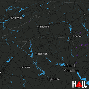 GREER (KGSP) RADAR

