This weather event on May 10, 2025 includes:
3 states
17 counties,
31 cities,
and 62 zip codes.
There were 2723 total properties that were impacted and have possible damage.
States Impacted By Hail On May 10, 2025
Alabama
·
Florida
·
Georgia
Counties Impacted By Hail On May 10, 2025
Autauga, AL
·
Coffee, AL
·
Dallas, AL
·
Geneva, AL
·
Henry, AL
·
Houston, AL
·
Bay, FL
·
Holmes, FL
·
Jackson, FL
·
Walton, FL
·
Washington, FL
·
Calhoun, GA
·
Early, GA
·
Lee, GA
·
Randolph, GA
·
Sumter, GA
·
Terrell, GA
Cities Impacted By Hail On May 10, 2025
Ashford, AL
·
Black, AL
·
Chipley, FL
·
Cowarts, AL
·
Dawson, GA
·
Dothan, AL
·
Ebro, FL
·
Elba, AL
·
Esto, FL
·
Freeport, FL
·
Graceville, FL
·
Headland, AL
·
Kinsey, AL
·
Lynn Haven, FL
·
Malvern, AL
·
Marianna, FL
·
Morgan, GA
·
Panama City, FL
·
Panama City Beach, FL
·
Ponce de Leon, FL
·
Pretty Bayou, FL
·
Rehobeth, AL
·
Selmont-West Selmont, AL
·
Shellman, GA
·
Slocomb, AL
·
Taylor, AL
·
Upper Grand Lagoon, FL
·
Vernon, FL
·
Wausau, FL
·
Webb, AL
·
Westville, FL
Zip Codes Impacted By Hail On May 10, 2025
31709
·
31719
·
31763
·
31764
·
31787
·
32401
·
32403
·
32405
·
32407
·
32408
·
32409
·
32413
·
32420
·
32425
·
32427
·
32428
·
32431
·
32435
·
32437
·
32439
·
32440
·
32444
·
32446
·
32447
·
32448
·
32455
·
32462
·
32463
·
32464
·
32466
·
36003
·
36301
·
36303
·
36305
·
36312
·
36314
·
36319
·
36320
·
36321
·
36323
·
36343
·
36344
·
36345
·
36351
·
36370
·
36373
·
36375
·
36376
·
36701
·
36703
·
36749
·
36761
·
36767
·
36775
·
36785
·
39823
·
39826
·
39842
·
39846
·
39866
·
39886
·
32433
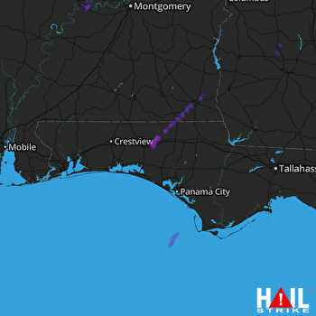 EGLIN AFB (KEVX) RADAR

