This weather event on May 8, 2025 includes:
3 states
25 counties,
24 cities,
and 59 zip codes.
There were 4556 total properties that were impacted and have possible damage.
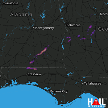 FORT RUCKER (KEOX) RADAR
States Impacted By Hail On May 8, 2025
Alabama
·
Florida
·
Georgia
Counties Impacted By Hail On May 8, 2025
Barbour, AL
·
Coffee, AL
·
Covington, AL
·
Crenshaw, AL
·
Dale, AL
·
Pike, AL
·
Okaloosa, FL
·
Walton, FL
·
Bibb, GA
·
Crawford, GA
·
Crisp, GA
·
Dooly, GA
·
Houston, GA
·
Lee, GA
·
Macon, GA
·
Marion, GA
·
Monroe, GA
·
Peach, GA
·
Quitman, GA
·
Randolph, GA
·
Stewart, GA
·
Sumter, GA
·
Turner, GA
·
Webster, GA
·
Worth, GA
Cities Impacted By Hail On May 8, 2025
Americus, GA
·
Babbie, AL
·
Brundidge, AL
·
Byromville, GA
·
Elba, AL
·
Florala, AL
·
Gantt, AL
·
Georgetown-Quitman County, GA
·
Horn Hill, AL
·
Laurel Hill, FL
·
Lilly, GA
·
Lumpkin, GA
·
Macon-Bibb County, GA
·
Marshallville, GA
·
Montezuma, GA
·
New Brockton, AL
·
Oglethorpe, GA
·
Onycha, AL
·
Opp, AL
·
Paxton, FL
·
Perry, GA
·
Sycamore, GA
·
Unadilla, GA
·
Webster County, GA
Zip Codes Impacted By Hail On May 8, 2025
31007
·
31015
·
31025
·
31029
·
31030
·
31050
·
31051
·
31052
·
31057
·
31063
·
31068
·
31069
·
31070
·
31091
·
31092
·
31220
·
31709
·
31711
·
31712
·
31714
·
31719
·
31743
·
31764
·
31780
·
31790
·
31796
·
31803
·
31815
·
31821
·
31824
·
32433
·
32531
·
32567
·
36005
·
36009
·
36010
·
36017
·
36028
·
36036
·
36041
·
36046
·
36048
·
36079
·
36311
·
36323
·
36346
·
36351
·
36360
·
36420
·
36421
·
36442
·
36453
·
36467
·
36483
·
39840
·
39867
·
32464
·
31787
·
31066

