This weather event on May 7, 2025 includes:
2 states
14 counties,
41 cities,
and 66 zip codes.
There were 24695 total properties that were impacted and have possible damage.
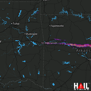 FORT SMITH (KSRX) RADAR
States Impacted By Hail On May 7, 2025
Arkansas
·
Oklahoma
Counties Impacted By Hail On May 7, 2025
Conway, AR
·
Crawford, AR
·
Faulkner, AR
·
Franklin, AR
·
Johnson, AR
·
Logan, AR
·
Pope, AR
·
Scott, AR
·
Sebastian, AR
·
White, AR
·
Yell, AR
·
Delaware, OK
·
Le Flore, OK
·
Sequoyah, OK
Cities Impacted By Hail On May 7, 2025
Atkins, AR
·
Barling, AR
·
Bonanza, AR
·
Central City, AR
·
Clarksville, AR
·
Coal Hill, AR
·
Copeland, OK
·
Damascus, AR
·
Dodge, OK
·
Dover, AR
·
Enola, AR
·
Fort Smith, AR
·
Greenbrier, AR
·
Greenwood, AR
·
Grove, OK
·
Guy, AR
·
Hagarville, AR
·
Hartman, AR
·
Kibler, AR
·
Knoxville, AR
·
Lamar, AR
·
Lavaca, AR
·
London, AR
·
Menifee, AR
·
Moffett, OK
·
Morrison Bluff, AR
·
Mount Vernon, AR
·
Mulberry, AR
·
Muldrow, OK
·
Ozark, AR
·
Pocola, OK
·
Pottsville, AR
·
Remy, OK
·
Roland, OK
·
Rose Bud, AR
·
Russellville, AR
·
Scranton, AR
·
Spiro, OK
·
Twin Groves, AR
·
Van Buren, AR
·
Wiederkehr Village, AR
Zip Codes Impacted By Hail On May 7, 2025
72012
·
72027
·
72032
·
72039
·
72047
·
72058
·
72061
·
72063
·
72080
·
72102
·
72107
·
72110
·
72111
·
72127
·
72131
·
72136
·
72137
·
72143
·
72156
·
72157
·
72801
·
72802
·
72821
·
72823
·
72824
·
72830
·
72832
·
72834
·
72835
·
72837
·
72840
·
72845
·
72846
·
72847
·
72855
·
72858
·
72863
·
72865
·
72901
·
72903
·
72904
·
72908
·
72916
·
72921
·
72928
·
72930
·
72933
·
72936
·
72937
·
72940
·
72941
·
72947
·
72949
·
72951
·
72956
·
72958
·
74331
·
74344
·
74901
·
74902
·
74930
·
74940
·
74946
·
74948
·
74954
·
74959

