This weather event on May 6, 2025 includes:
3 states
20 counties,
27 cities,
and 50 zip codes.
There were 1034 total properties that were impacted and have possible damage.
States Impacted By Hail On May 6, 2025
Alabama
·
Louisiana
·
Mississippi
Counties Impacted By Hail On May 6, 2025
Mobile, AL
·
Jefferson, LA
·
Livingston, LA
·
Orleans, LA
·
St. Charles, LA
·
St. John the Baptist, LA
·
St. Tammany, LA
·
Tangipahoa, LA
·
Washington, LA
·
Amite, MS
·
George, MS
·
Hancock, MS
·
Harrison, MS
·
Jackson, MS
·
Lawrence, MS
·
Lincoln, MS
·
Pearl River, MS
·
Perry, MS
·
Pike, MS
·
Stone, MS
Cities Impacted By Hail On May 6, 2025
Ama, LA
·
Bogue Chitto, MS
·
Boutte, LA
·
Brookhaven, MS
·
Elmwood, LA
·
Hammond, LA
·
Harahan, LA
·
Jefferson, LA
·
Kenner, LA
·
Killian, LA
·
Lacombe, LA
·
Laplace, LA
·
Luling, LA
·
McComb, MS
·
Metairie, LA
·
Monticello, MS
·
New Orleans, LA
·
Pearl River, LA
·
Picayune, MS
·
Ponchatoula, LA
·
Reserve, LA
·
River Ridge, LA
·
Saucier, MS
·
Springfield, LA
·
St. Rose, LA
·
Summit, MS
·
Waggaman, LA
Zip Codes Impacted By Hail On May 6, 2025
36587
·
39452
·
39456
·
39466
·
39470
·
39503
·
39556
·
39561
·
39562
·
39565
·
39571
·
39573
·
39574
·
39577
·
39601
·
39629
·
39641
·
39648
·
39652
·
39654
·
39662
·
39663
·
39665
·
39666
·
70001
·
70002
·
70003
·
70005
·
70031
·
70039
·
70062
·
70068
·
70070
·
70084
·
70094
·
70121
·
70123
·
70403
·
70426
·
70427
·
70443
·
70448
·
70449
·
70452
·
70454
·
70462
·
70711
·
70744
·
70445
·
70087
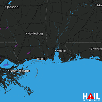 MOBILE (KMOB) RADAR

