This weather event on May 1, 2025 includes:
4 states
18 counties,
27 cities,
and 73 zip codes.
There were total properties that were impacted and have possible damage.
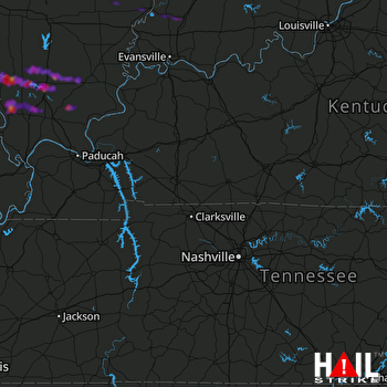 FORT CAMPBELL (KHPX) RADAR
States Impacted By Hail On May 1, 2025
Illinois
·
Indiana
·
Kentucky
·
Missouri
Counties Impacted By Hail On May 1, 2025
Clay, IL
·
Edwards, IL
·
Franklin, IL
·
Jackson, IL
·
Johnson, IL
·
Pope, IL
·
Richland, IL
·
Saline, IL
·
Union, IL
·
Wabash, IL
·
Wayne, IL
·
Williamson, IL
·
Gibson, IN
·
Martin, IN
·
Orange, IN
·
Adair, KY
·
Cape Girardeau, MO
·
Perry, MO
Cities Impacted By Hail On May 1, 2025
Alto Pass, IL
·
Bush, IL
·
Cambria, IL
·
Carbondale, IL
·
Carterville, IL
·
Cobden, IL
·
Crainville, IL
·
De Soto, IL
·
Energy, IL
·
Francisco, IN
·
Freeman Spur, IL
·
French Lick, IN
·
Harrisburg, IL
·
Harrison, IL
·
Herrin, IL
·
Hurst, IL
·
Johnsonville, IL
·
Johnston City, IL
·
Makanda, IL
·
Marion, IL
·
Murphysboro, IL
·
Pittsburg, IL
·
Princeton, IN
·
Royalton, IL
·
West Baden Springs, IN
·
West Frankfort, IL
·
Zeigler, IL
Zip Codes Impacted By Hail On May 1, 2025
42642
·
42728
·
47432
·
47469
·
47581
·
47649
·
47660
·
47665
·
47666
·
47670
·
62446
·
62476
·
62806
·
62815
·
62818
·
62823
·
62824
·
62833
·
62841
·
62842
·
62850
·
62863
·
62865
·
62868
·
62878
·
62890
·
62896
·
62901
·
62902
·
62905
·
62906
·
62907
·
62912
·
62915
·
62918
·
62920
·
62921
·
62922
·
62924
·
62932
·
62933
·
62935
·
62939
·
62942
·
62946
·
62947
·
62948
·
62949
·
62950
·
62951
·
62958
·
62959
·
62966
·
62967
·
62972
·
62974
·
62975
·
62977
·
62983
·
62985
·
62987
·
62995
·
62998
·
62999
·
63732
·
63748
·
63755
·
63769
·
63770
·
63783
·
62917
·
62940
·
62952

