This weather event on April 30, 2025 includes:
3 states
38 counties,
3 cities,
and 69 zip codes.
There were 183 total properties that were impacted and have possible damage.
States Impacted By Hail On April 30, 2025
Kansas
·
Oklahoma
·
Texas
Counties Impacted By Hail On April 30, 2025
Barton, KS
·
Edwards, KS
·
Finney, KS
·
Ford, KS
·
Gove, KS
·
Gray, KS
·
Greeley, KS
·
Hamilton, KS
·
Hodgeman, KS
·
Kearny, KS
·
Kingman, KS
·
Lincoln, KS
·
Logan, KS
·
Morton, KS
·
Ness, KS
·
Pawnee, KS
·
Pratt, KS
·
Rawlins, KS
·
Reno, KS
·
Russell, KS
·
Seward, KS
·
Sheridan, KS
·
Sherman, KS
·
Stafford, KS
·
Thomas, KS
·
Trego, KS
·
Wallace, KS
·
Wichita, KS
·
Beaver, OK
·
Ellis, OK
·
Harper, OK
·
Texas, OK
·
Woodward, OK
·
Hansford, TX
·
Hutchinson, TX
·
Lipscomb, TX
·
Ochiltree, TX
·
Roberts, TX
Cities Impacted By Hail On April 30, 2025
Greeley County unified government (balance), KS
·
Jetmore, KS
·
Tribune, KS
Zip Codes Impacted By Hail On April 30, 2025
67455
·
67490
·
67521
·
67523
·
67525
·
67530
·
67544
·
67550
·
67552
·
67557
·
67563
·
67576
·
67578
·
67583
·
67631
·
67634
·
67701
·
67732
·
67733
·
67735
·
67736
·
67738
·
67740
·
67743
·
67745
·
67748
·
67752
·
67761
·
67764
·
67801
·
67835
·
67838
·
67839
·
67846
·
67849
·
67851
·
67853
·
67854
·
67859
·
67860
·
67861
·
67869
·
67876
·
67878
·
67879
·
67882
·
67953
·
67954
·
73801
·
73841
·
73843
·
73848
·
73851
·
73901
·
73931
·
73942
·
73944
·
73945
·
73950
·
79033
·
79034
·
79059
·
79065
·
79070
·
79080
·
79081
·
79093
·
67035
·
67545
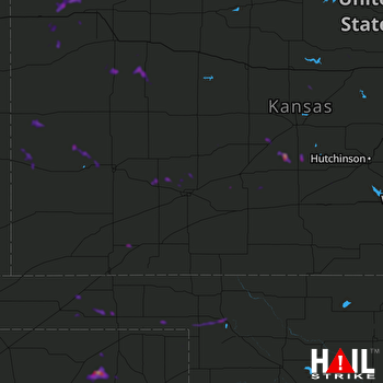 DODGE CITY (KDDC) RADAR

