This weather event on April 30, 2025 includes:
2 states
27 counties,
12 cities,
and 45 zip codes.
There were total properties that were impacted and have possible damage.
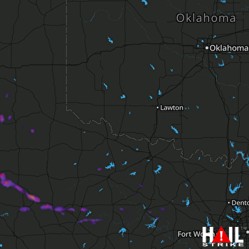 ALTUS AFB (KFDR) RADAR
States Impacted By Hail On April 30, 2025
Oklahoma
·
Texas
Counties Impacted By Hail On April 30, 2025
Tillman, OK
·
Archer, TX
·
Armstrong, TX
·
Baylor, TX
·
Briscoe, TX
·
Callahan, TX
·
Crosby, TX
·
Dickens, TX
·
Donley, TX
·
Eastland, TX
·
Foard, TX
·
Hall, TX
·
Hardeman, TX
·
Haskell, TX
·
Jack, TX
·
Jones, TX
·
Kent, TX
·
King, TX
·
Knox, TX
·
Motley, TX
·
Palo Pinto, TX
·
Shackelford, TX
·
Stonewall, TX
·
Throckmorton, TX
·
Wichita, TX
·
Wilbarger, TX
·
Young, TX
Cities Impacted By Hail On April 30, 2025
Aspermont, TX
·
Baird, TX
·
Crosbyton, TX
·
Elbert, TX
·
Girard, TX
·
Graham, TX
·
Haskell, TX
·
Jayton, TX
·
Olney, TX
·
Spur, TX
·
Stamford, TX
·
Wichita Falls, TX
Zip Codes Impacted By Hail On April 30, 2025
73530
·
76302
·
76308
·
76310
·
76351
·
76360
·
76366
·
76367
·
76372
·
76374
·
76380
·
76384
·
76424
·
76427
·
76430
·
76437
·
76449
·
76450
·
76458
·
76469
·
76483
·
76491
·
79201
·
79226
·
79227
·
79252
·
79255
·
79257
·
79322
·
79357
·
79370
·
79502
·
79503
·
79504
·
79518
·
79528
·
79533
·
79540
·
79546
·
79547
·
79548
·
79549
·
79553
·
79521
·
79261

