Hail Map For April 28, 2025 (KMAF)

This weather event on April 28, 2025 includes: 2 states 26 counties, 8 cities, and 41 zip codes.
There were 3334 total properties that were impacted and have possible damage.
Preview image 
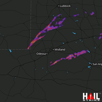
MIDLAND/ODSSA (KMAF) RADAR
Weather Data Verified By
Data provided by NOAA. Data provided by NWS.

Impact Score

3

Hail Size

Average 1.8"
Maximum 3"

Storm Details

Start Time
03:08 PM
Properties
3334
Spotters
2
GROUND VERIFIED

States Impacted By Hail On April 28, 2025

New Mexico · Texas

Counties Impacted By Hail On April 28, 2025

Lea, NM · Andrews, TX · Borden, TX · Coke, TX · Crane, TX · Crosby, TX · Dawson, TX · Dickens, TX · Fisher, TX · Gaines, TX · Garza, TX · Glasscock, TX · Jones, TX · Kent, TX · King, TX · Lynn, TX · Midland, TX · Nolan, TX · Pecos, TX · Reagan, TX · Sterling, TX · Stonewall, TX · Taylor, TX · Terry, TX · Upton, TX · Winkler, TX

Cities Impacted By Hail On April 28, 2025

Girard, TX · Jal, NM · Lamesa, TX · Merkel, TX · O'Donnell, TX · Sterling City, TX · Tahoka, TX · Tye, TX

Zip Codes Impacted By Hail On April 28, 2025

76932 · 76945 · 76951 · 79236 · 79316 · 79322 · 79330 · 79331 · 79342 · 79351 · 79356 · 79357 · 79360 · 79370 · 79373 · 79377 · 79381 · 79501 · 79502 · 79517 · 79518 · 79520 · 79525 · 79528 · 79536 · 79537 · 79549 · 79556 · 79561 · 79563 · 79603 · 79706 · 79714 · 79731 · 79735 · 79738 · 79739 · 79745 · 79752 · 79755 · 88252