This weather event on April 27, 2025 includes:
3 states
31 counties,
26 cities,
and 72 zip codes.
There were 1520 total properties that were impacted and have possible damage.
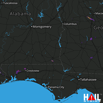 FORT RUCKER (KEOX) RADAR
States Impacted By Hail On April 27, 2025
Alabama
·
Florida
·
Georgia
Counties Impacted By Hail On April 27, 2025
Baldwin, AL
·
Covington, AL
·
Dale, AL
·
Geneva, AL
·
Henry, AL
·
Houston, AL
·
Escambia, FL
·
Okaloosa, FL
·
Santa Rosa, FL
·
Ben Hill, GA
·
Berrien, GA
·
Calhoun, GA
·
Colquitt, GA
·
Cook, GA
·
Crawford, GA
·
Crisp, GA
·
Dodge, GA
·
Dooly, GA
·
Early, GA
·
Houston, GA
·
Lanier, GA
·
Lee, GA
·
Lowndes, GA
·
Macon, GA
·
Peach, GA
·
Pulaski, GA
·
Sumter, GA
·
Talbot, GA
·
Taylor, GA
·
Wilcox, GA
·
Worth, GA
Cities Impacted By Hail On April 27, 2025
Byron, GA
·
Centerville, GA
·
Chumuckla, FL
·
Cordele, GA
·
Crestview, FL
·
Dothan, AL
·
East Milton, FL
·
Fort Valley, GA
·
Leesburg, GA
·
Loxley, AL
·
Malvern, AL
·
Midland City, AL
·
Moultrie, GA
·
Munson, FL
·
Newton, AL
·
Newville, AL
·
Norman Park, GA
·
Pinckard, AL
·
Pitts, GA
·
Rehobeth, AL
·
Riverside, GA
·
Roeville, FL
·
Seville, GA
·
Springhill, FL
·
Taylor, AL
·
Warner Robins, GA
Zip Codes Impacted By Hail On April 27, 2025
31005
·
31006
·
31007
·
31008
·
31011
·
31015
·
31023
·
31028
·
31030
·
31036
·
31050
·
31052
·
31058
·
31063
·
31066
·
31071
·
31072
·
31084
·
36373
·
31711
·
31088
·
31091
·
31092
·
31093
·
31605
·
31620
·
31632
·
31645
·
31709
·
31712
·
31719
·
31743
·
31750
·
31756
·
31763
·
31765
·
31768
·
31771
·
31772
·
31780
·
31787
·
31788
·
31796
·
31827
·
32531
·
32535
·
32536
·
32539
·
32564
·
32567
·
32568
·
32570
·
32571
·
32583
·
36301
·
36303
·
36305
·
36320
·
36322
·
36345
·
36350
·
36352
·
36353
·
36360
·
36371
·
36374
·
36442
·
36467
·
36507
·
36567
·
39813
·
39823

