This weather event on April 26, 2025 includes:
2 states
29 counties,
16 cities,
and 64 zip codes.
There were 12745 total properties that were impacted and have possible damage.
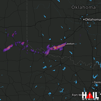 ALTUS AFB (KFDR) RADAR
States Impacted By Hail On April 26, 2025
Oklahoma
·
Texas
Counties Impacted By Hail On April 26, 2025
Comanche, OK
·
Cotton, OK
·
Garvin, OK
·
Grady, OK
·
Greer, OK
·
Harmon, OK
·
Jackson, OK
·
Major, OK
·
McClain, OK
·
Roger Mills, OK
·
Stephens, OK
·
Tillman, OK
·
Armstrong, TX
·
Briscoe, TX
·
Carson, TX
·
Childress, TX
·
Collingsworth, TX
·
Cottle, TX
·
Donley, TX
·
Foard, TX
·
Gray, TX
·
Hall, TX
·
Hardeman, TX
·
King, TX
·
Knox, TX
·
Motley, TX
·
Wheeler, TX
·
Wichita, TX
·
Wilbarger, TX
Cities Impacted By Hail On April 26, 2025
Bradley, OK
·
Central High, OK
·
Chattanooga, OK
·
Childress, TX
·
Chillicothe, TX
·
Davidson, OK
·
Faxon, OK
·
Frederick, OK
·
Hollis, OK
·
Hollister, OK
·
Lawton, OK
·
Memphis, TX
·
Quitaque, TX
·
Roaring Springs, TX
·
Tipton, OK
·
Turkey, TX
Zip Codes Impacted By Hail On April 26, 2025
73002
·
73011
·
73052
·
73055
·
73082
·
73501
·
73503
·
73505
·
73507
·
73521
·
73527
·
73528
·
73530
·
73531
·
73533
·
73537
·
73538
·
73539
·
73540
·
73542
·
73543
·
73544
·
73546
·
73547
·
73549
·
73550
·
73551
·
73552
·
73553
·
73555
·
73560
·
73566
·
73570
·
73572
·
73628
·
73660
·
76364
·
76367
·
76384
·
79019
·
79039
·
79057
·
79065
·
79068
·
79079
·
79201
·
79225
·
79226
·
79227
·
79230
·
79233
·
79237
·
79239
·
79244
·
79245
·
79248
·
79251
·
79252
·
79255
·
79256
·
79259
·
79261
·
79505
·
73838

