This weather event on April 25, 2025 includes:
3 states
20 counties,
18 cities,
and 53 zip codes.
There were 7121 total properties that were impacted and have possible damage.
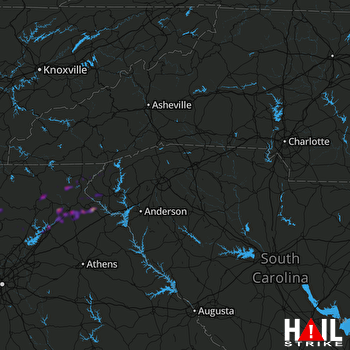 GREER (KGSP) RADAR
States Impacted By Hail On April 25, 2025
Georgia
·
North Carolina
·
South Carolina
Counties Impacted By Hail On April 25, 2025
Banks, GA
·
Dawson, GA
·
Forsyth, GA
·
Gilmer, GA
·
Habersham, GA
·
Hall, GA
·
Lumpkin, GA
·
Madison, GA
·
Pickens, GA
·
Rabun, GA
·
Stephens, GA
·
Towns, GA
·
Union, GA
·
Walton, GA
·
White, GA
·
Cherokee, NC
·
Greenville, SC
·
Oconee, SC
·
Pickens, SC
·
Spartanburg, SC
Cities Impacted By Hail On April 25, 2025
Alto, GA
·
Baldwin, GA
·
Clayton, GA
·
Cornelia, GA
·
Demorest, GA
·
Five Forks, SC
·
Gainesville, GA
·
Golden Grove, SC
·
Greenville, SC
·
Lula, GA
·
Mauldin, SC
·
Mountain City, GA
·
Mount Airy, GA
·
Raoul, GA
·
Simpsonville, SC
·
Taylors, SC
·
Toccoa, GA
·
Wade Hampton, SC
Zip Codes Impacted By Hail On April 25, 2025
29605
·
29607
·
29615
·
29630
·
29650
·
29651
·
29662
·
29664
·
29673
·
29680
·
29681
·
29685
·
29686
·
29687
·
29691
·
29693
·
30028
·
30052
·
30107
·
30143
·
30148
·
30175
·
30501
·
30504
·
30506
·
30510
·
30511
·
30512
·
30523
·
30525
·
30527
·
30528
·
30531
·
30533
·
30534
·
30535
·
30536
·
30538
·
30545
·
30546
·
30552
·
30554
·
30562
·
30563
·
30568
·
30572
·
30576
·
30577
·
30581
·
30633
·
30571
·
29676
·
28906

