This weather event on April 23, 2025 includes:
2 states
31 counties,
11 cities,
and 52 zip codes.
There were 4317 total properties that were impacted and have possible damage.
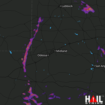 MIDLAND/ODSSA (KMAF) RADAR
States Impacted By Hail On April 23, 2025
New Mexico
·
Texas
Counties Impacted By Hail On April 23, 2025
Lea, NM
·
Andrews, TX
·
Bailey, TX
·
Brewster, TX
·
Coke, TX
·
Crockett, TX
·
Crosby, TX
·
Dickens, TX
·
Fisher, TX
·
Floyd, TX
·
Gaines, TX
·
Jeff Davis, TX
·
Kent, TX
·
King, TX
·
Loving, TX
·
Nolan, TX
·
Pecos, TX
·
Presidio, TX
·
Reeves, TX
·
Runnels, TX
·
Schleicher, TX
·
Stonewall, TX
·
Sutton, TX
·
Taylor, TX
·
Terrell, TX
·
Terry, TX
·
Tom Green, TX
·
Val Verde, TX
·
Ward, TX
·
Winkler, TX
·
Yoakum, TX
Cities Impacted By Hail On April 23, 2025
Alpine, TX
·
Barstow, TX
·
Denver City, TX
·
Eunice, NM
·
Girard, TX
·
Jal, NM
·
Marathon, TX
·
Nadine, NM
·
Sonora, TX
·
Spur, TX
·
Winters, TX
Zip Codes Impacted By Hail On April 23, 2025
76821
·
76861
·
76865
·
76905
·
76933
·
76936
·
76943
·
76950
·
76953
·
79220
·
79229
·
79235
·
79236
·
79243
·
79316
·
79322
·
79323
·
79355
·
79359
·
79360
·
79370
·
79371
·
79376
·
79378
·
79502
·
79506
·
79518
·
79528
·
79537
·
79541
·
79543
·
79556
·
79562
·
79566
·
79567
·
79714
·
79719
·
79734
·
79735
·
79745
·
79754
·
79772
·
79781
·
79789
·
79830
·
79831
·
79842
·
79843
·
79848
·
88231
·
88240
·
88252

