This weather event on April 22, 2025 includes:
3 states
19 counties,
16 cities,
and 52 zip codes.
There were 7774 total properties that were impacted and have possible damage.
States Impacted By Hail On April 22, 2025
Georgia
·
North Carolina
·
South Carolina
Counties Impacted By Hail On April 22, 2025
Hancock, GA
·
Warren, GA
·
Anson, NC
·
Cumberland, NC
·
Harnett, NC
·
Hoke, NC
·
Montgomery, NC
·
Moore, NC
·
Richmond, NC
·
Scotland, NC
·
Union, NC
·
Chester, SC
·
Chesterfield, SC
·
Lancaster, SC
·
Laurens, SC
·
Lexington, SC
·
Marlboro, SC
·
McCormick, SC
·
Union, SC
Cities Impacted By Hail On April 22, 2025
Carlisle, SC
·
Cayce, SC
·
Chester, SC
·
Fort Lawn, SC
·
Foxfire, NC
·
Gaston, SC
·
Oak Grove, SC
·
Pine Ridge, SC
·
Red Bank, SC
·
Richburg, SC
·
Seven Lakes, NC
·
South Congaree, SC
·
Springdale, SC
·
Spring Lake, NC
·
Vass, NC
·
West Columbia, SC
Zip Codes Impacted By Hail On April 22, 2025
27229
·
27242
·
27281
·
27306
·
27325
·
27376
·
28091
·
28112
·
28119
·
28133
·
28135
·
28170
·
28315
·
28326
·
28338
·
28345
·
28350
·
28379
·
28394
·
29014
·
29031
·
29033
·
29053
·
29067
·
29073
·
29123
·
29169
·
29170
·
29172
·
29178
·
29325
·
29360
·
29379
·
29512
·
29596
·
29645
·
29704
·
29706
·
29709
·
29714
·
29718
·
29720
·
29727
·
29728
·
29729
·
29741
·
29835
·
29848
·
30821
·
30828
·
31087
·
28327
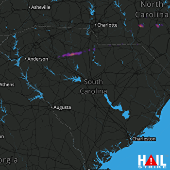 COLUMBIA (KCAE) RADAR

